
ملف:Americas satellite map.jpg

الملف الأصلي (2٬300 × 2٬900 بكسل حجم الملف: 1٫87 ميجابايت، نوع MIME: image/jpeg)
| هذا ملف من ويكيميديا كومنز. معلومات من صفحة وصفه مبينة في الأسفل. كومنز مستودع ملفات ميديا ذو رخصة حرة. |
ملخص
| الوصف |
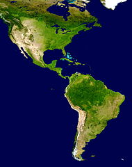
NASA's description of the original non-cropped imageː "This spectacular “blue marble” image is the most detailed true-color image of the entire Earth to date. Using a collection of satellite-based observations, scientists and visualizers stitched together months of observations of the land surface, oceans, sea ice, and clouds into a seamless, true-color mosaic of every square kilometer (.386 square mile) of our planet. These images are freely available to educators, scientists, museums, and the public. This record includes preview images and links to full resolution versions up to 21,600 pixels across. Much of the information contained in this image came from a single remote-sensing device-NASA’s Moderate Resolution Imaging Spectroradiometer, or MODIS. Flying over 700 km above the Earth onboard the Terra satellite, MODIS provides an integrated tool for observing a variety of terrestrial, oceanic, and atmospheric features of the Earth. The land and coastal ocean portions of these images are based on surface observations collected from June through September 2001 and combined, or composited, every eight days to compensate for clouds that might block the sensor’s view of the surface on any single day. Two different types of ocean data were used in these images: shallow water true color data, and global ocean color (or chlorophyll) data. Topographic shading is based on the GTOPO 30 elevation dataset compiled by the U.S. Geological Survey’s EROS Data Center. MODIS observations of polar sea ice were combined with observations of Antarctica made by the National Oceanic and Atmospheric Administration’s AVHRR sensor—the Advanced Very High Resolution Radiometer. The cloud image is a composite of two days of imagery collected in visible light wavelengths and a third day of thermal infra-red imagery over the poles. Global city lights, derived from 9 months of observations from the Defense Meteorological Satellite Program, are superimposed on a darkened land surface map." The 8192 x 4096 TIFF NASA global map has been cropped, adjusted in brightness, and converted to JPEG. |
| التاريخ | |
| المصدر | http://visibleearth.nasa.gov/view_rec.php?id=2433 |
| المؤلف | NASA |
| إصدارات أخرى | أَعمالٌ مُشتقَّة مِن هذا الملفِّ: Distribution of P. peckolti.jpg |
ترخيص
| يقع هذا العمل في النِّطاق العامّ في الولايات المُتحدة الأمريكيَّة لأَنَّه عملٌ خالِصٌ من إِنتاج وكالة الفضاء الأمريكيَّة. تنصُ حقوق التَّأليف والنَّشر الخاصَّة بوكالة الفضاء الأمريكيَّة على أنَّ "أعمال الوكالة غير مَحميَّة بحقوق التَّأليف والنَّشر ما لم يُذكر خلافُ ذلك". لمزيدٍ من المعلومات انظر القالِب {{PD-USGov}} وصفحة حقوق التَّأليف والنَّشر الخاصَّة بالوكالة وصفحة سياسة الصُّور الخاصَّة بمُختبر الدَّفع النَّفَّاث. | ||
 |
تنبيهات:
|
تاريخ الملف
اضغط على زمن/تاريخ لرؤية الملف كما بدا في هذا الزمن.
| زمن/تاريخ | صورة مصغرة | الأبعاد | مستخدم | تعليق | |
|---|---|---|---|---|---|
| حالي | 17:23، 28 يونيو 2008 | | 2٬300 × 2٬900 (1٫87 ميجابايت) | WolfmanSF | {{Information |Description=This spectacular “blue marble” image is the most detailed true-color image of the entire Earth to date. Using a collection of satellite-based observations, scientists and visualizers stitched together months of observations |
| 19:54، 30 ديسمبر 2007 |  | 2٬300 × 2٬900 (1٫93 ميجابايت) | WolfmanSF | {{Information |Description=This spectacular “blue marble” image is the most detailed true-color image of the entire Earth to date. Using a collection of satellite-based observations, scientists and visualizers stitched together months of observations |
استخدام الملف
الصفحة التالية تستخدم هذا الملف:
الاستخدام العالمي للملف
الويكيات الأخرى التالية تستخدم هذا الملف:
- الاستخدام في bn.wikipedia.org
- الاستخدام في ca.wikipedia.org
- الاستخدام في ca.wikiquote.org
- الاستخدام في ckb.wikipedia.org
- الاستخدام في en.wikipedia.org
- الاستخدام في es.wikipedia.org
- América del Norte
- Colombia
- Haití
- Dominica
- Portal:Geografía/Titular
- Comando Sur de Estados Unidos
- Portal:América
- Policía Nacional de la República Dominicana
- Wikiproyecto:América del Sur/Proyectos hermanos
- Anexo:Supercentenarios latinoamericanos
- Categoría:Elecciones en América en 1993
- Categoría:Elecciones en América en 1913
- Categoría:Elecciones en América en 1992
- Categoría:Elecciones en América en 1996
- Categoría:Elecciones en América en 1995
- Categoría:Elecciones en América en 1997
- Categoría:Elecciones en América en 1994
- Categoría:Elecciones en América en 1965
- Categoría:Elecciones en América en 1960
- Anexo:Imperios americanos
- Categoría:Elecciones en América en 1991
- Categoría:Elecciones en América en 1990
- Categoría:Elecciones en América en 1989
- Categoría:Elecciones en América en 1988
- Categoría:Elecciones en América en 1987
- Categoría:Elecciones en América en 1985
- Categoría:Elecciones en América en 1984
- Categoría:Elecciones en América en 1983
- Categoría:Elecciones en América en 1915
- Categoría:Elecciones en América en 1937
- الاستخدام في es.wikivoyage.org
- الاستخدام في eu.wikipedia.org
- الاستخدام في fa.wikipedia.org
- الاستخدام في ff.wikipedia.org
اعرض المزيد من الاستخدام العام لهذا الملف.