
ملف:Challenger Deep EM124 Sonar Map and Diving History 101119.jpg
حجم هذه المعاينة: 800 × 366 بكسل. الأبعاد الأخرى: 320 × 146 بكسل | 640 × 292 بكسل | 1٬278 × 584 بكسل.
الملف الأصلي (1٬278 × 584 بكسل حجم الملف: 141 كيلوبايت، نوع MIME: image/jpeg)
| هذا ملف من ويكيميديا كومنز. معلومات من صفحة وصفه مبينة في الأسفل. كومنز مستودع ملفات ميديا ذو رخصة حرة. |
ملخص
| الوصف |
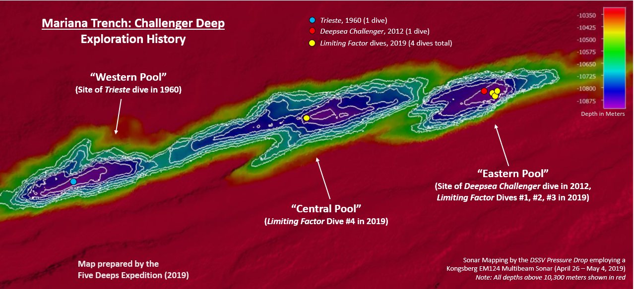
English: This map was created by the DSSV Pressure Drop's Kngsberg EM124 sonar system over the course of two weeks to map the Challenger Deep in the Marianas Trench. The Deep consists of three "pools" of varying depth with the central pool being the most shallow, then the western one, with the eastern pool measured to be the deepest at 10,925 meters. That depth was measured using the manned submersible DSV Limiting Factor on April 28 - May 3, 2019 as part of the Five Deeps Expedition. |
| التاريخ | |
| المصدر | عمل شخصي |
| المؤلف | Vlvescovo |
ترخيص
أنا، صاحب حقوق التأليف والنشر لهذا العمل، أنشر هذا العمل تحت الرخصة التالية:
هذا الملفُّ مُرخَّصٌ برخصة المشاع الإبداعي الدَّوليَّة المُلزِمة بنسب العمل إلى مُؤَلِّفه وبترخيص المُشتقَّات بالمثل 4.0.
- يحقُّ لك:
- مشاركة العمل – نسخ العمل وتوزيعه وبثُّه
- إعادة إنتاج العمل – تعديل العمل
- حسب الشروط التالية:
- نسب العمل إلى مُؤَلِّفه – يلزم نسب العمل إلى مُؤَلِّفه بشكل مناسب وتوفير رابط للرخصة وتحديد ما إذا أجريت تغييرات. بالإمكان القيام بذلك بأية طريقة معقولة، ولكن ليس بأية طريقة تشير إلى أن المرخِّص يوافقك على الاستعمال.
- الإلزام بترخيص المُشتقات بالمثل – إذا أعدت إنتاج المواد أو غيرت فيها، فيلزم أن تنشر مساهماتك المُشتقَّة عن الأصل تحت ترخيص الأصل نفسه أو تحت ترخيص مُتوافِقٍ معه.
تاريخ الملف
اضغط على زمن/تاريخ لرؤية الملف كما بدا في هذا الزمن.
| زمن/تاريخ | صورة مصغرة | الأبعاد | مستخدم | تعليق | |
|---|---|---|---|---|---|
| حالي | 22:06، 11 أكتوبر 2019 | | 1٬278 × 584 (141 كيلوبايت) | Vlvescovo | User created page with UploadWizard |
استخدام الملف
الصفحة التالية تستخدم هذا الملف:
الاستخدام العالمي للملف
الويكيات الأخرى التالية تستخدم هذا الملف:
- الاستخدام في de.wikipedia.org
- الاستخدام في en.wikipedia.org
- الاستخدام في ga.wikipedia.org
- الاستخدام في ka.wikipedia.org
- الاستخدام في lv.wikipedia.org
- الاستخدام في pl.wikipedia.org