
ملف:Manchukuo map 1939.svg

حجم معاينة PNG لذلك الملف ذي الامتداد SVG: 634 × 387 بكسل. الأبعاد الأخرى: 320 × 195 بكسل | 640 × 391 بكسل | 1٬024 × 625 بكسل | 1٬280 × 781 بكسل | 2٬560 × 1٬563 بكسل.
الملف الأصلي (ملف SVG، أبعاده 634 × 387 بكسل، حجم الملف: 2٫27 ميجابايت)
| هذا ملف من ويكيميديا كومنز. معلومات من صفحة وصفه مبينة في الأسفل. كومنز مستودع ملفات ميديا ذو رخصة حرة. |
| الوصف |
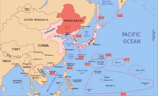
English: A map of the Manchukuo, 1939-09-01. Dates shown indicate the approximate year that Japan gain control of the possession. Japanese control of territory in China was tenuous. |
| التاريخ | |
| المصدر | |
| المؤلف |
|
| إصدارات أخرى |
|


أنا، صاحب حقوق التأليف والنشر لهذا العمل، أنشر هذا العمل تحت الرخص التالية:
هذا الملفُّ مُرخَّص بموجب رخصة المشاع الإبداعي نسبة المُصنَّف إِلى مُؤَلِّفه - المشاركة بالمثل 3.0 العامة
- يحقُّ لك:
- مشاركة العمل – نسخ العمل وتوزيعه وبثُّه
- إعادة إنتاج العمل – تعديل العمل
- حسب الشروط التالية:
- نسب العمل إلى مُؤَلِّفه – يلزم نسب العمل إلى مُؤَلِّفه بشكل مناسب وتوفير رابط للرخصة وتحديد ما إذا أجريت تغييرات. بالإمكان القيام بذلك بأية طريقة معقولة، ولكن ليس بأية طريقة تشير إلى أن المرخِّص يوافقك على الاستعمال.
- الإلزام بترخيص المُشتقات بالمثل – إذا أعدت إنتاج المواد أو غيرت فيها، فيلزم أن تنشر مساهماتك المُشتقَّة عن الأصل تحت ترخيص الأصل نفسه أو تحت ترخيص مُتوافِقٍ معه.

|
يسمح نسخ وتوزيع و/أو تعديل هذه الوثيقة تحت شروط رخصة جنو للوثائق الحرة، الإصدار 1.2 أو أي إصدار لاحق تنشره مؤسسة البرمجيات الحرة؛ دون أقسام ثابتة ودون نصوص أغلفة أمامية ودون نصوص أغلفة خلفية. نسخة من الرخصة تم تضمينها في القسم المسمى GNU Free Documentation License. |
لك أن تختار الرخصة التي تناسبك.
سجلُّ الرَّفع الأصيل
This image is a derivative work of the following images:
- Image:Pacific_Area_-_The_Imperial_Powers_1939_-_Map.svg licensed with Cc-by-sa-3.0, GFDL
- 2008-08-08T01:16:33Z Emok 1039x814 (4678233 Bytes) {{Information |Description= |Source= |Date= |Author= |Permission= |other_versions= }}
- 2008-08-08T00:07:48Z Emok 1039x814 (4669659 Bytes) {{Information |Description= |Source= |Date= |Author= |Permission= |other_versions= }}
- 2008-08-07T05:03:23Z Emok 1039x814 (4669195 Bytes) {{Information |Description= |Source= |Date= |Author= |Permission= |other_versions= }}
- 2008-08-07T04:28:58Z Emok 1039x814 (4623405 Bytes) {{Information |Description= |Source= |Date= |Author= |Permission= |other_versions= }}
- 2008-08-07T04:02:57Z Emok 1039x814 (4602891 Bytes) {{Information |Description= |Source= |Date= |Author= |Permission= |other_versions= }}
- 2008-08-07T03:24:03Z Emok 1039x814 (4669511 Bytes) {{Information |Description= |Source= |Date= |Author= |Permission= |other_versions= }}
- 2008-08-04T16:59:39Z Emok 1039x814 (6442489 Bytes) {{Information |Description= |Source= |Date= |Author= |Permission= |other_versions= }}
- 2008-08-04T05:38:24Z Emok 1039x814 (6427678 Bytes) {{Information |Description= |Source= |Date= |Author= |Permission= |other_versions= }} [[Category:Imperialism]] [[Category:Oceania]]
- 2008-08-04T05:26:00Z Emok 104x82 (4765313 Bytes) {{Information |Description={{en|1=A map of the Imperial Powers of the Pacific, 1939-09-01. }} |Source=*[[:Image:World2Hires_filled_mercator.svg|]] |Date=2008-08-04 05:22 (UTC) |Author=*derivative work: ~~~ *[[:Image:World2Hir
Uploaded with derivativeFX
تاريخ الملف
اضغط على زمن/تاريخ لرؤية الملف كما بدا في هذا الزمن.
| زمن/تاريخ | صورة مصغرة | الأبعاد | مستخدم | تعليق | |
|---|---|---|---|---|---|
| حالي | 08:25، 21 مايو 2024 | | 634 × 387 (2٫27 ميجابايت) | Andrei Stroe | File uploaded using svgtranslate tool (https://svgtranslate.toolforge.org/). Added translation for ro. |
| 14:48، 16 سبتمبر 2023 |  | 634 × 387 (2٫23 ميجابايت) | KajenCAT | File uploaded using svgtranslate tool (https://svgtranslate.toolforge.org/). Added translation for ca. | |
| 15:17، 2 يونيو 2023 |  | 634 × 387 (2٫2 ميجابايت) | SmallJarsWithGreenLabels | re-applying sp changes because this site sucks and gave me the old version of the svg for my second edit | |
| 23:33، 1 يونيو 2023 |  | 634 × 387 (2٫2 ميجابايت) | SmallJarsWithGreenLabels | saipan per user:Geographyinitiative | |
| 23:18، 1 يونيو 2023 |  | 634 × 387 (2٫19 ميجابايت) | SmallJarsWithGreenLabels | sp | |
| 01:37، 27 أغسطس 2010 |  | 634 × 387 (2٫21 ميجابايت) | Splittist | No reason for Xinjiang to have separate borders from China | |
| 23:29، 30 مايو 2009 |  | 634 × 387 (2٫21 ميجابايت) | SelfQ~commonswiki | Cluttering and removal of key elements is not acceptable. If you want a Chineese version please upload on under its own file name. | |
| 10:44، 17 مايو 2009 |  | 1٬300 × 1٬201 (864 كيلوبايت) | Xiamipi | 增加中文说明 | |
| 02:52، 21 أغسطس 2008 |  | 634 × 387 (2٫21 ميجابايت) | Emok | {{Information |Description= |Source= |Date= |Author= |Permission= |other_versions= }} | |
| 02:41، 21 أغسطس 2008 |  | 634 × 387 (2٫21 ميجابايت) | Emok | {{Information |Description= |Source= |Date= |Author= |Permission= |other_versions= }} |
استخدام الملف
الصفحة التالية تستخدم هذا الملف:
الاستخدام العالمي للملف
الويكيات الأخرى التالية تستخدم هذا الملف:
- الاستخدام في azb.wikipedia.org
- الاستخدام في az.wikipedia.org
- الاستخدام في bg.wikipedia.org
- الاستخدام في bs.wikipedia.org
- الاستخدام في ca.wikipedia.org
- الاستخدام في da.wikipedia.org
- الاستخدام في el.wikipedia.org
- الاستخدام في en.wikipedia.org
- الاستخدام في fa.wikipedia.org
- الاستخدام في fr.wikipedia.org
- الاستخدام في hr.wikipedia.org
- الاستخدام في hy.wikipedia.org
- الاستخدام في id.wikipedia.org
- الاستخدام في it.wikipedia.org
- الاستخدام في ja.wikipedia.org
- الاستخدام في ja.wikibooks.org
- الاستخدام في jv.wikipedia.org
- الاستخدام في lt.wikipedia.org
- الاستخدام في lv.wikipedia.org
- الاستخدام في mk.wikipedia.org
- الاستخدام في mn.wikipedia.org
- الاستخدام في ms.wikipedia.org
- الاستخدام في no.wikipedia.org
- الاستخدام في pt.wikipedia.org
- الاستخدام في ro.wikipedia.org
- الاستخدام في sh.wikipedia.org
- الاستخدام في simple.wikipedia.org
- الاستخدام في sl.wikipedia.org
- الاستخدام في sr.wikipedia.org
- الاستخدام في ta.wikipedia.org
- الاستخدام في uk.wikipedia.org
- الاستخدام في uz.wikipedia.org