
ملف:Map of Izu Islands.png

حجم هذه المعاينة: 535 × 600 بكسل. الأبعاد الأخرى: 214 × 240 بكسل | 428 × 480 بكسل | 685 × 768 بكسل | 1٬257 × 1٬409 بكسل.
الملف الأصلي (1٬257 × 1٬409 بكسل حجم الملف: 691 كيلوبايت، نوع MIME: image/png)
| هذا ملف من ويكيميديا كومنز. معلومات من صفحة وصفه مبينة في الأسفل. كومنز مستودع ملفات ميديا ذو رخصة حرة. |
ملخص
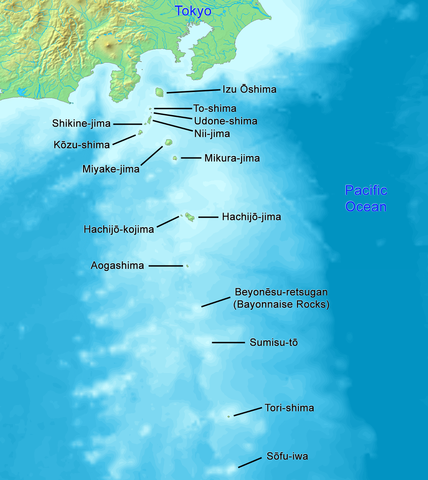
| الوصف |
English: High quality map of the Izu Islands. This is the English (Romaji) version with Japanese names. Created with DEMIS World Map Server.
日本語: 日本語:高品質の地図、伊豆諸島。 |
| التاريخ | |
| المصدر | عمل شخصي |
| المؤلف | Artanisen |
| إصدارات أخرى |
|

ترخيص
This image is in the public domain because it came from the site https://www.demis.nl/products/web-map-server/examples/ and was released by the copyright holder. Permission is granted to copy, distribute and/or modify this map since it is based on free of copyright images from: www.demis.nl. See also approval email on de.wp and its clarification.
|
| This work has been released into the public domain by its copyright holder, www.demis.nl. This applies worldwide. في بعض البلدان، قد يكون هذا التَّرخيص غيرَ مُمكنٍ قانونيَّاً، في هذه الحالة: يمنح www.demis.nl الجميع حق استخدام هذا العمل لأي غرض دون أي شرط ما لم يفرض القانون شروطًا إضافية.
|

|
هذه map الصورة / الصورتان باستعمال رسومات متجهية ملفات رسوميات شعاعية.
It is recommended to name the SVG file "Map of Izu Islands.svg" - then the template Vector version available (or Vva) does not need the new image name parameter.
|
تاريخ الملف
اضغط على زمن/تاريخ لرؤية الملف كما بدا في هذا الزمن.
| زمن/تاريخ | صورة مصغرة | الأبعاد | مستخدم | تعليق | |
|---|---|---|---|---|---|
| حالي | 01:04، 24 ديسمبر 2021 | | 1٬257 × 1٬409 (691 كيلوبايت) | Artanisen | Reverted to version as of 10:15, 2 October 2019 (UTC) reverted to names in English only, because there is a separate Japanese map |
| 07:22، 21 أكتوبر 2019 |  | 1٬257 × 1٬409 (771 كيلوبايت) | Artanisen | Added Japanese kanji of the island names and thinner black lines. | |
| 10:15، 2 أكتوبر 2019 |  | 1٬257 × 1٬409 (691 كيلوبايت) | Artanisen | English: High quality map of the Izu Islands. Created with DEMIS World Map Server. 日本語:高品質の地図、伊豆諸島。 | |
| 14:51، 5 أكتوبر 2006 |  | 300 × 400 (32 كيلوبايت) | Tdk~commonswiki | Map of Izu Islands. Created with DEMIS World Map Server.{{demis-pd}} |
استخدام الملف
ال3 صفحات التالية تستخدم هذا الملف:
الاستخدام العالمي للملف
الويكيات الأخرى التالية تستخدم هذا الملف:
- الاستخدام في az.wikipedia.org
- الاستخدام في bn.wikipedia.org
- الاستخدام في ca.wikipedia.org
- الاستخدام في ceb.wikipedia.org
- الاستخدام في ckb.wikipedia.org
- الاستخدام في cs.wikipedia.org
- الاستخدام في da.wikipedia.org
- الاستخدام في el.wikipedia.org
- الاستخدام في en.wikipedia.org
- Geography of Japan
- Tokyo
- List of islands of Japan
- Devil's Sea
- Izu Islands
- Nii-jima
- Kōzu-shima
- Portal:Japan
- Shikine-jima
- Izu Ōshima
- Mikura-jima
- Lot's Wife (crag)
- Aogashima
- Tori-shima (Izu Islands)
- Hachijō-kojima
- Smith Island (Japan)
- Inamba-jima
- Udone-shima
- Ōnohara Islands
- Bayonnaise Rocks
- Hachijō language
- Jinai-tō
- List of governors of the Nanpō Islands
- Seven Islands of Izu
- الاستخدام في en.wikibooks.org
- الاستخدام في en.wikivoyage.org
- الاستخدام في eo.wikipedia.org
- الاستخدام في es.wikipedia.org
- الاستخدام في eu.wikipedia.org
- الاستخدام في fa.wikipedia.org
اعرض المزيد من الاستخدام العام لهذا الملف.