ملف:Morphometry of Concepcion Bank. Evidence of Geological and Biological Processes on a Large Volcanic Seamount of the Canary Islands Seamount Province. 2016 Rivera et al. Fig. 1.PNG

محتويات الصفحة غير مدعومة بلغات أخرى.
من ويكيبيديا، الموسوعة الحرة

الملف الأصلي(2٬207 × 2٬109 بكسل حجم الملف: 1٫37 ميجابايت، نوع MIME: image/png)

ملخص

الوصف
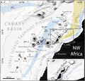
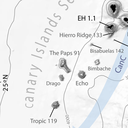
English: Fig 1. General bathymetric map of the Canary Islands Seamount Province (CISP).

Note the seamounts, islands and other relevant physiographic features as well as the regional surface current system. The Canary Basin, the Canary Ridge, the Canary Channel and its diapir belt extending northwards are indicated. Numbers attached to seamounts and islands represent individual oldest age estimate where available, after Van den Bogaard [28]. AC: Azores Current. CC: Canary Current. CUC: Canary Upwelling Current. NEC: North EquatorialCurrent. SV: Selvagens. L: Lanzarote. F: Fuerteventura. GC: Gran Canaria. TF: Tenerife. LP: La Palma. EH: El Hierro. Bathymetry in meters from GEBCO.

DOI: 10.1371/journal.pone.0156337
التاريخ
المصدر Rivera, J. et al. (2016). "Morphometry of Concepcion Bank: Evidence of Geological and Biological Processes on a Large Volcanic Seamount of the Canary Islands Seamount Province". PLoS ONE 11 (5). DOI:10.1371/journal.pone.0156337. (Fig. 1: [1])
المؤلف © 2016 Rivera et al
الترخيص
(إعادة استخدام هذا الملف)
w:ar:مشاع إبداعي
نسب العمل إلى مُؤَلِّفه
هذا الملف مرخص تحت ترخيص المشاع الإبداعي الدولية المُلزِمة بنسب العمل إلى مُؤلِّفه 4.0.
يحقُّ لك:
  • مشاركة العمل – نسخ العمل وتوزيعه وبثُّه
  • إعادة إنتاج العمل – تعديل العمل
حسب الشروط التالية:
  • نسب العمل إلى مُؤَلِّفه – يلزم نسب العمل إلى مُؤَلِّفه بشكل مناسب وتوفير رابط للرخصة وتحديد ما إذا أجريت تغييرات. بالإمكان القيام بذلك بأية طريقة معقولة، ولكن ليس بأية طريقة تشير إلى أن المرخِّص يوافقك على الاستعمال.
رُوجِع هذا الملفُّ الذي نشر أوَّلاً في الموقع Rivera, J. et al. (2016). "Morphometry of Concepcion Bank: Evidence of Geological and Biological Processes on a Large Volcanic Seamount of the Canary Islands Seamount Province". PLoS ONE 11 (5). DOI:10.1371/journal.pone.0156337. (Fig. 1: [2])، بتاريخ 14 April 2018 من قبل المُراجِع Leoboudv الذي أكَّد أنَّه كان مُتوافِراً في ذلك المَوقع في ذلك التاريخ تحت الرُّخصة المُشار إِليها.
إصدارات أخرى

الشروحات

أضف شرحاً من سطر واحد لما يُمثِّله هذا الملف

العناصر المصورة في هذا الملف

يُصوِّر

٣١ مايو 2016

تاريخ الملف

اضغط على زمن/تاريخ لرؤية الملف كما بدا في هذا الزمن.

زمن/تاريخصورة مصغرةالأبعادمستخدمتعليق
حالي05:37، 14 أبريل 2018تصغير للنسخة بتاريخ 05:37، 14 أبريل 20182٬207 × 2٬109 (1٫37 ميجابايت)Asqueladd== {{int:filedesc}} == {{Information |description={{en|1='''Fig 1. General bathymetric map of the Canary Islands Seamount Province (CISP).'''<br /><br />Note the seamounts, islands and other relevant physiographic features as well as the regional surface current system. The Canary Basin, the Canary Ridge, the Canary Channel and its diapir belt extending northwards are indicated. Numbers attached to seamounts and islands represent individual oldest age estimate where available, after Van den B...

الصفحة التالية تستخدم هذا الملف:

الاستخدام العالمي للملف

الويكيات الأخرى التالية تستخدم هذا الملف:

بيانات وصفية