
ملف:Mwamongu water source.jpg

الملف الأصلي (946 × 768 بكسل حجم الملف: 344 كيلوبايت، نوع MIME: image/jpeg)
| هذا ملف من ويكيميديا كومنز. معلومات من صفحة وصفه مبينة في الأسفل. كومنز مستودع ملفات ميديا ذو رخصة حرة. |
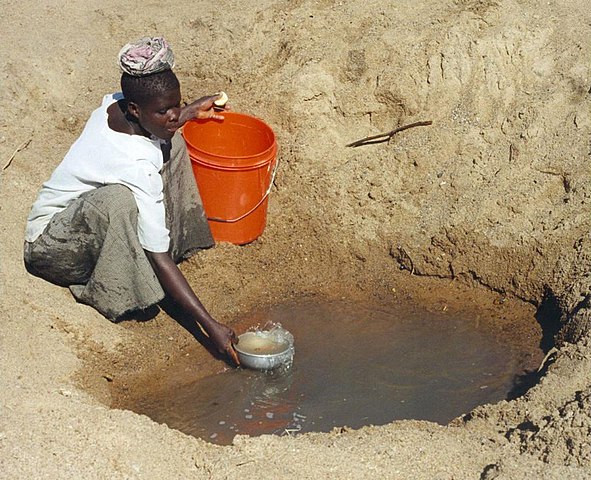
| الوصف |
English: Mwamanongu Village water source, Tanzania. "In Meatu district, Shinyanga region, Tanzania, water most often comes from open holes dug in the sand of dry riverbeds, and it is invariably contaminated." .
Français : Point d'eau du village de Mwamanongu, en Tanzanie. "Dans le district de Meatu (région de Shinyanga, Tanzanie), L'eau provient le plus souvent de trous creusés dans le sable de lits de rivières asséchées. Elle est systématiquement contaminée." |
||
| التاريخ | |||
| المصدر |
http://solarcooking.wikia.com/wiki/Image:Mwamongu_water_source.jpg, |
||
| المؤلف | Bob Metcalf | ||
| الترخيص (إعادة استخدام هذا الملف) |
|
| موقع الكاميرا | | هذه وغيرها من الصور في مواقعها على: خريطة الشارع المفتوحة |
|---|
Location note from author: If one goes north from the city of Tabora, follow it to Shinyanga. Shinyanga town is the administrative location of the Shinyanga Region, which includes several districts, Meatu District being one of them. From Shinyanga, go east to find the town of Mhunze, which I think is what I know as Mwanhuze, the District headquarters. It was from Mhunze that we took a Land Rover a bit northwest, I think, perhaps 15 km, to reach Mwamanongu. The driver knew how to get to these villages, but there were no road signs anywhere, nor any landmarks on the flat land, and the 'road' was just a path, often in lousy condition for the rare vehicle that would use it.
Editor's note: Mwanhuze and Mwamanongu are wards in en:Meatu District.[1] Meatu is a trapezoidal region that borders the western end of Lake Eyasi and extends roughly 70 km to the northwest.[2] Mhunze is a ward in en:Bariadi District. Walter Siegmund (talk) 05:02, 14 January 2008 (UTC)

|
قُيِّمت هذه الصورة وفقاً لمعايير تقييم الصُّور، ونتيجةً لذلك، فإنها تعدُّ صورةً ذات قيمةٍ عاليةٍ في كُومِنز في نطاق: Primitive water supply. يُمكن أيضاً مُراجعة صفحة ترشيح الصُّورة للتقييم. |
تاريخ الملف
اضغط على زمن/تاريخ لرؤية الملف كما بدا في هذا الزمن.
| زمن/تاريخ | صورة مصغرة | الأبعاد | مستخدم | تعليق | |
|---|---|---|---|---|---|
| حالي | 23:39، 12 يناير 2008 | | 946 × 768 (344 كيلوبايت) | Wsiegmund | PE; cropped white borders |
| 23:38، 12 يناير 2008 |  | 1٬024 × 768 (149 كيلوبايت) | Wsiegmund | Upload slightly larger version | |
| 14:58، 12 يناير 2008 |  | 944 × 704 (85 كيلوبايت) | Wsiegmund | {{Information |Description=Mwamongu Village water source, Tanzania |Source=Wikia:c:solarcooking:Image:Mwamongu_water_source.jpg |Date=2006-06-06 |Author=Bob Metcalf |Permission={{PD-author|Bob Metcalf}} |other_versions= }} |
استخدام الملف
الصفحتان التاليتان تستخدمان هذا الملف:
الاستخدام العالمي للملف
الويكيات الأخرى التالية تستخدم هذا الملف:
- الاستخدام في af.wikipedia.org
- الاستخدام في ca.wikipedia.org
- الاستخدام في da.wikipedia.org
- الاستخدام في de.wikipedia.org
- الاستخدام في de.wikibooks.org
- الاستخدام في de.wiktionary.org
- الاستخدام في el.wikipedia.org
- الاستخدام في en.wikipedia.org
- الاستخدام في en.wikibooks.org
- الاستخدام في en.wikiversity.org
- الاستخدام في en.wiktionary.org
- الاستخدام في es.wikipedia.org
- الاستخدام في eu.wikipedia.org
- الاستخدام في fi.wikipedia.org
- الاستخدام في fr.wikipedia.org
- الاستخدام في fr.wiktionary.org
- الاستخدام في ga.wikipedia.org
- الاستخدام في gur.wikipedia.org
- الاستخدام في he.wikipedia.org
- الاستخدام في hi.wikipedia.org
- الاستخدام في hu.wikibooks.org
- الاستخدام في id.wikipedia.org
- الاستخدام في ig.wikipedia.org
- الاستخدام في io.wiktionary.org
- الاستخدام في it.wikipedia.org
اعرض المزيد من الاستخدام العام لهذا الملف.