
ملف:Pentagon road network map 1945.jpg

حجم هذه المعاينة: 470 × 599 بكسل. الأبعاد الأخرى: 188 × 240 بكسل | 377 × 480 بكسل | 1٬020 × 1٬300 بكسل.
الملف الأصلي (1٬020 × 1٬300 بكسل حجم الملف: 535 كيلوبايت، نوع MIME: image/jpeg)
| هذا ملف من ويكيميديا كومنز. معلومات من صفحة وصفه مبينة في الأسفل. كومنز مستودع ملفات ميديا ذو رخصة حرة. |
تقع هذه الصُّورة في النِّطاق العامّ لأنَّها تحتوي مواد حصريَّة مِن إِنتاج هيئة المساحة الجيولوجيَّة الأمريكيَّة في وزارة الداخلية في الولايات المُتحدة الأمريكيَّة. للمزيد مِن المعلومات انظر سياسية حقوق التَّأليف والنَّشر في موقع هيئة المساحة الجيولوجيَّة الأمريكيَّة الرسميَّة.
|
| الوصف |
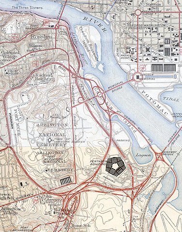
USGS topos covering the area around the Pentagon in Virginia, soon after the road network was built. Note that the Shirley Highway near the south edge of the map was added later, as it opened in 1943. |
|||||||||
| المصدر |
|
|||||||||
| Geotemporal data | ||||||||||
| Bounding box |
|
|||||||||
| Georeferencing | ||||||||||
تاريخ الملف
اضغط على زمن/تاريخ لرؤية الملف كما بدا في هذا الزمن.
| زمن/تاريخ | صورة مصغرة | الأبعاد | مستخدم | تعليق | |
|---|---|---|---|---|---|
| حالي | 19:31، 21 يناير 2006 | | 1٬020 × 1٬300 (535 كيلوبايت) | SPUI~commonswiki | {{PD-USGov-USGS}} USGS topos covering the area around the Pentagon in Virginia, soon after the road network was built. Note that the Shirley Highway near the southwest edge of the map was added later, as it opened in 1943. *North half: [http://historical. |
استخدام الملف
الصفحة التالية تستخدم هذا الملف:
الاستخدام العالمي للملف
الويكيات الأخرى التالية تستخدم هذا الملف:
- الاستخدام في ast.wikipedia.org
- الاستخدام في ca.wikipedia.org
- الاستخدام في da.wikipedia.org
- الاستخدام في de.wikipedia.org
- الاستخدام في el.wikipedia.org
- الاستخدام في en.wikipedia.org
- الاستخدام في et.wikipedia.org
- الاستخدام في ga.wikipedia.org
- الاستخدام في he.wikipedia.org
- الاستخدام في hr.wikipedia.org
- الاستخدام في hy.wikipedia.org
- الاستخدام في it.wikipedia.org
- الاستخدام في ja.wikipedia.org
- الاستخدام في kn.wikipedia.org
- الاستخدام في pl.wikipedia.org
- الاستخدام في pnb.wikipedia.org
- الاستخدام في tr.wikipedia.org
- الاستخدام في uz.wikipedia.org
- الاستخدام في www.wikidata.org