
ملف:Satellite Image of Earth's Interrelated Systems and Climate - GPN-2002-000121.jpg

حجم هذه المعاينة: 600 × 600 بكسل. الأبعاد الأخرى: 240 × 240 بكسل | 480 × 480 بكسل | 768 × 768 بكسل | 1٬024 × 1٬024 بكسل | 2٬350 × 2٬350 بكسل.
الملف الأصلي (2٬350 × 2٬350 بكسل حجم الملف: 1٫28 ميجابايت، نوع MIME: image/jpeg)
| هذا ملف من ويكيميديا كومنز. معلومات من صفحة وصفه مبينة في الأسفل. كومنز مستودع ملفات ميديا ذو رخصة حرة. |
| الوصف |
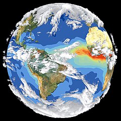
English: Satellite data and images such as those presented in this image of Earth give scientists a more comprehensive view of the Earth's interrelated systems and climate. Four different satellites contributed to the making of this image. Sea-viewing Wide Field-of-view Sensor (SeaWiFS) provided the land image layer and is a true color composite of land vegetation for cloud-free conditions from September 18 to October 3, 1997. Each red dot over South America and Africa represents a fire detected by the Advanced Very High Resolution Radiometer. The oceanic aerosol layer is based on National Oceanic and Atmospheric Administration (NOAA) data and is caused by biomass burning and windblown dust over Africa. The cloud layer is a composite of infrared images from four geostationary weather satellites?NOAA's GOES 8 and 9, the European Space Agency's METEOSAT, and Japan's GMS 5. |
|||||
| التاريخ | ||||||
| المصدر | Great Images in NASA Description | |||||
| المؤلف | NASA | |||||
| الترخيص (إعادة استخدام هذا الملف) |
|

فُهرِست هذه الصُّورة أَو هذا التَّسجيل المرئي لدى Goddard Space Flight Center التَّابعة لوكالة الفضاء الأَمريكيَّة (ناسا) تحت المُعرِّف GPN-2002-000121 و المُعرِّف البديل : 119. لا يُشير هذه الوَسم إلى حالة حقوق التَّأليف والنَّشر الخاصَّة بالعمل المُرفَق؛ لا يزال وَسم حقوق التَّأليف والنَّشر مَطلُوباً، راجع كومنز:ترخيص لمزيدٍ من المعلومات. لغات أخرى:
|
تاريخ الملف
اضغط على زمن/تاريخ لرؤية الملف كما بدا في هذا الزمن.
| زمن/تاريخ | صورة مصغرة | الأبعاد | مستخدم | تعليق | |
|---|---|---|---|---|---|
| حالي | 07:50، 14 أبريل 2015 | | 2٬350 × 2٬350 (1٫28 ميجابايت) | Jcpag2012 | cropped from black borders |
| 22:54، 9 أبريل 2009 |  | 2٬700 × 3٬214 (2٫91 ميجابايت) | BotMultichillT | {{Information |Description={{en|1=Satellite data and images such as those presented in this image of Earth give scientists a more comprehensive view of the Earth's interrelated systems and climate. Four different satellites contributed to the making of th |
استخدام الملف
الصفحة التالية تستخدم هذا الملف:
الاستخدام العالمي للملف
الويكيات الأخرى التالية تستخدم هذا الملف:
- الاستخدام في de.wikipedia.org
- الاستخدام في el.wikipedia.org
- الاستخدام في en.wikipedia.org
- الاستخدام في it.wikipedia.org
- الاستخدام في no.wikipedia.org