
ملف:Southwest map.png

حجم هذه المعاينة: 800 × 520 بكسل. الأبعاد الأخرى: 320 × 208 بكسل | 640 × 416 بكسل | 1٬024 × 666 بكسل | 1٬280 × 832 بكسل.
الملف الأصلي (1٬280 × 832 بكسل حجم الملف: 199 كيلوبايت، نوع MIME: image/png)
| هذا ملف من ويكيميديا كومنز. معلومات من صفحة وصفه مبينة في الأسفل. كومنز مستودع ملفات ميديا ذو رخصة حرة. |
ملخص
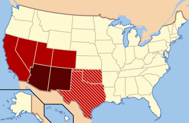
| الوصف |
Dark Red: Almost always considered the Southwest |
| التاريخ | |
| المصدر | عمل شخصي |
| المؤلف | Secret Saturdays |
ترخيص
| أنا، مالِك حقوق تأليف ونشر هذا العمل، أجعله في النِّطاق العامِّ، يسري هذا في أرجاء العالم كلِّه. في بعض البلدان، قد يكون هذا التَّرخيص غيرَ مُمكنٍ قانونيَّاً، في هذه الحالة: أمنح الجميع حق استخدام هذا العمل لأي غرض دون أي شرط ما لم يفرض القانون شروطًا إضافية. |
تاريخ الملف
اضغط على زمن/تاريخ لرؤية الملف كما بدا في هذا الزمن.
| زمن/تاريخ | صورة مصغرة | الأبعاد | مستخدم | تعليق | |
|---|---|---|---|---|---|
| حالي | 03:20، 9 فبراير 2022 | | 1٬280 × 832 (199 كيلوبايت) | Quackslikeaduck | Reverted to version as of 20:03, 25 August 2016 (UTC); Kansas is not considered part of the American Southwest, not even geographically. |
| 21:39، 31 يوليو 2020 |  | 1٬280 × 832 (159 كيلوبايت) | Rubensbathsheba | Kansas may sometimes be considered part of the Southwest geographically. | |
| 20:03، 25 أغسطس 2016 |  | 1٬280 × 832 (199 كيلوبايت) | WClarke | Instead of using dark red, red, and blue stripes, this version uses dark red, red, and red stripes. Everything being red makes the map look more uniform. | |
| 22:53، 23 يوليو 2009 |  | 572 × 371 (21 كيلوبايت) | Secret Saturdays | {{Information |Description={{en|1=The Dark Red states mean they are almost always considered Southwest states, The light red states mean they are rarely considered Southwest states and the Blue States mean they are conisdered Southwest and Southern states |
استخدام الملف
الصفحتان التاليتان تستخدمان هذا الملف:
الاستخدام العالمي للملف
الويكيات الأخرى التالية تستخدم هذا الملف:
- الاستخدام في cs.wikipedia.org
- الاستخدام في de.wikipedia.org
- الاستخدام في en.wikipedia.org
- الاستخدام في eo.wikipedia.org
- الاستخدام في fy.wikipedia.org
- الاستخدام في he.wikipedia.org
- الاستخدام في id.wikipedia.org
- الاستخدام في ko.wikipedia.org
- الاستخدام في ru.wikipedia.org
- الاستخدام في sv.wikipedia.org
- الاستخدام في tr.wikipedia.org
- الاستخدام في ur.wikipedia.org
- الاستخدام في vi.wikipedia.org
- الاستخدام في www.wikidata.org