
ملف:Soviet Union Administrative Divisions 1989.jpg

حجم هذه المعاينة: 800 × 557 بكسل. الأبعاد الأخرى: 320 × 223 بكسل | 640 × 445 بكسل | 1٬024 × 713 بكسل | 1٬280 × 891 بكسل | 1٬887 × 1٬313 بكسل.
الملف الأصلي (1٬887 × 1٬313 بكسل حجم الملف: 397 كيلوبايت، نوع MIME: image/jpeg)
| هذا ملف من ويكيميديا كومنز. معلومات من صفحة وصفه مبينة في الأسفل. كومنز مستودع ملفات ميديا ذو رخصة حرة. |
ملخص
| الوصف |
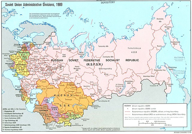
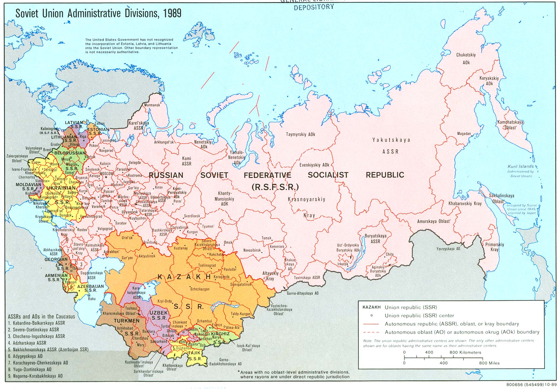
English: An American map of Soviet Union Administrative Divisions c.1989 |
||
| المصدر |
|
||
| المؤلف | |||
| إصدارات أخرى |
|


ترخيص
| هذا العمل مِن مَجمُوعة في مكتبة الكونغرس، وفقاً للمكتبة، ليس هناك قيود معروفة لحقوق التَّأليف والنَّشر مُرتبِطة باستخدام هذا العمل. |  |
تاريخ الملف
اضغط على زمن/تاريخ لرؤية الملف كما بدا في هذا الزمن.
| زمن/تاريخ | صورة مصغرة | الأبعاد | مستخدم | تعليق | |
|---|---|---|---|---|---|
| حالي | 14:21، 17 مايو 2019 | | 1٬887 × 1٬313 (397 كيلوبايت) | Claude Zygiel | Removed stains |
| 07:39، 17 ديسمبر 2006 |  | 1٬887 × 1٬313 (413 كيلوبايت) | Electionworld | {{ew|en|Ma GioZal}} Soviet Union administrative divisions (republics) and sub-divisions (oblasts, autonomous republics, autonomous districs, etc.) in the year 1989, the last before the process of independence of Soviet republics after the [[Berlin Wa |
استخدام الملف
الصفحة التالية تستخدم هذا الملف:
الاستخدام العالمي للملف
الويكيات الأخرى التالية تستخدم هذا الملف:
- الاستخدام في af.wikipedia.org
- الاستخدام في ast.wikipedia.org
- الاستخدام في azb.wikipedia.org
- الاستخدام في az.wikipedia.org
- الاستخدام في az.wiktionary.org
- الاستخدام في bg.wikipedia.org
- الاستخدام في ca.wikipedia.org
- الاستخدام في cs.wikipedia.org
- الاستخدام في en.wikipedia.org
- History of the Soviet Union (1982–1991)
- History of Russia
- Soviet Union
- Republics of the Soviet Union
- Buryats
- Ukrainian Soviet Socialist Republic
- Uzbek Soviet Socialist Republic
- Republics of Russia
- Soviet people
- Portal:Maps/Maps/Political
- Portal:Maps/Maps/Political/8
- User:Seryo93/USSR
- Russian Soviet Federative Socialist Republic
- Portal:Soviet Union
- Great Russian chauvinism
- Russia–Ukraine border
- Russian imperialism
- User:Falcaorib/Russia and Soviet Union
- الاستخدام في en.wikiquote.org
- الاستخدام في es.wikipedia.org
- الاستخدام في fa.wikipedia.org
- الاستخدام في fi.wikipedia.org
- الاستخدام في fr.wikipedia.org
اعرض المزيد من الاستخدام العام لهذا الملف.