
ملف:Suhongtu site - Sinornithomimus quarry.png

حجم هذه المعاينة: 800 × 529 بكسل. الأبعاد الأخرى: 320 × 211 بكسل | 640 × 423 بكسل | 1٬147 × 758 بكسل.
الملف الأصلي (1٬147 × 758 بكسل حجم الملف: 496 كيلوبايت، نوع MIME: image/png)
| هذا ملف من ويكيميديا كومنز. معلومات من صفحة وصفه مبينة في الأسفل. كومنز مستودع ملفات ميديا ذو رخصة حرة. |
ملخص
| الوصف |
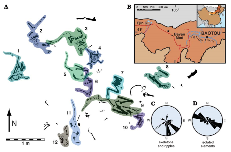
English: Suhongtu site, partial quarry map, locality map, and orientation data. A. Map of the central and northern portions of site showing the position of 12 of 13 skeletons. Skeletons 3 and 4 enlarged in Fig. 3. B. Fossil locality (41°17’ 10”N, 103°52’38”E) located 90 km northwest of Bayan Mod, InnerMongolia, China. C. Rose−diagram showing trends for skeletons (black, numbers denote skeleton count) and ripples (white). D. Mirror rose−diagram of elongated, isolated elements (n=13). Trends of skeletons have a strong, non−random (p<0.002) alignment to southeast. Flow direction of ripples is roughly perpendicular to that of elongate elements. |
| التاريخ | |
| المصدر | (2008). "Mud-Trapped Herd Captures Evidence of Distinctive Dinosaur Sociality". Acta Palaeontologica Polonica 53 (4): 567–578. DOI:10.4202/app.2008.0402. ISSN 0567-7920. |
| المؤلف | David J. Varricchio, Paul C. Sereno, Zhao Xi-jin, Tan Lin Jeffrey A. Wilson & Gabrielle H. Lyon |
ترخيص
هذا الملف مرخص تحت ترخيص المشاع الإبداعي الدولية المُلزِمة بنسب العمل إلى مُؤلِّفه 4.0.
- يحقُّ لك:
- مشاركة العمل – نسخ العمل وتوزيعه وبثُّه
- إعادة إنتاج العمل – تعديل العمل
- حسب الشروط التالية:
- نسب العمل إلى مُؤَلِّفه – يلزم نسب العمل إلى مُؤَلِّفه بشكل مناسب وتوفير رابط للرخصة وتحديد ما إذا أجريت تغييرات. بالإمكان القيام بذلك بأية طريقة معقولة، ولكن ليس بأية طريقة تشير إلى أن المرخِّص يوافقك على الاستعمال.
تاريخ الملف
اضغط على زمن/تاريخ لرؤية الملف كما بدا في هذا الزمن.
| زمن/تاريخ | صورة مصغرة | الأبعاد | مستخدم | تعليق | |
|---|---|---|---|---|---|
| حالي | 05:28، 21 أغسطس 2020 | | 1٬147 × 758 (496 كيلوبايت) | PaleoNeolitic | {{Information |description ={{en|1=Suhongtu site, partial quarry map, locality map, and orientation data. '''A'''. Map of the central and northern portions of site showing the position of 12 of 13 skeletons. Skeletons 3 and 4 enlarged in Fig. 3. '''B'''. Fossil locality (41°17’ 10”N, 103°52’38”E) located 90 km northwest of Bayan Mod, InnerMongolia, China. '''C'''. Rose−diagram showing trends for skeletons (black, numbers denote skeleton count) and ripples (white). '''D'''. Mirror rose−diagr... |
استخدام الملف
الصفحة التالية تستخدم هذا الملف:
الاستخدام العالمي للملف
الويكيات الأخرى التالية تستخدم هذا الملف:
- الاستخدام في ca.wikipedia.org
- الاستخدام في cs.wikipedia.org
- الاستخدام في en.wikipedia.org
- الاستخدام في he.wikipedia.org
- الاستخدام في hu.wikipedia.org
- الاستخدام في sv.wikipedia.org
- الاستخدام في www.wikidata.org
- الاستخدام في zh.wikipedia.org