
ملف:US Northeastern states.png

حجم هذه المعاينة: 800 × 520 بكسل. الأبعاد الأخرى: 320 × 208 بكسل | 640 × 416 بكسل | 1٬024 × 665 بكسل | 1٬513 × 983 بكسل.
الملف الأصلي (1٬513 × 983 بكسل حجم الملف: 46 كيلوبايت، نوع MIME: image/png)
| هذا ملف من ويكيميديا كومنز. معلومات من صفحة وصفه مبينة في الأسفل. كومنز مستودع ملفات ميديا ذو رخصة حرة. |
ملخص
| الوصف |
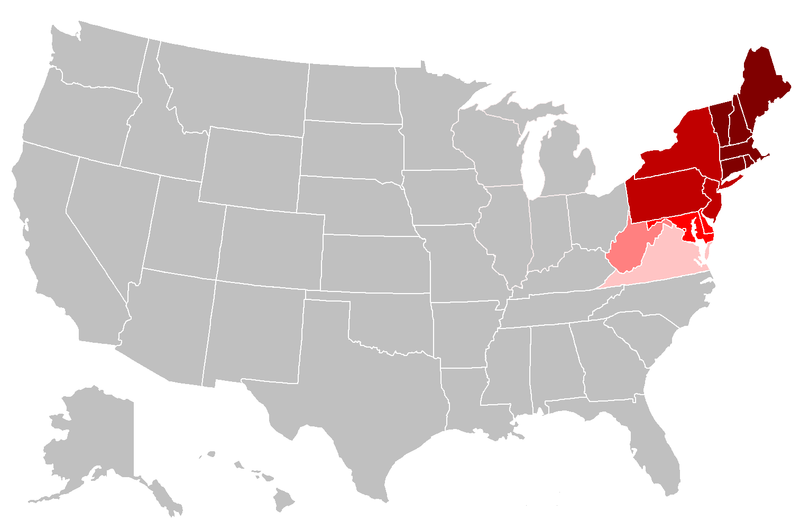
English: Map of the northeastern United States. The pink areas include states that are cited by fewer reliable sources as being included in the Northeast. The red areas are more frequently cited by reliable sources, and the dark red are the most commonly accepted as being included in the Northeast. |
| التاريخ | |
| المصدر | عمل شخصي, File:BlankMap-USA-states.PNG |
| المؤلف | Grayshi, Roke, Maher-shalal-hashbaz |
ترخيص
أنا، صاحب حقوق التأليف والنشر لهذا العمل، أنشر هذا العمل تحت الرخص التالية:
هذا الملفُّ مُرخَّص بموجب رخصة المشاع الإبداعي نسبة المُصنَّف إِلى مُؤَلِّفه - المشاركة بالمثل 3.0 العامة
- يحقُّ لك:
- مشاركة العمل – نسخ العمل وتوزيعه وبثُّه
- إعادة إنتاج العمل – تعديل العمل
- حسب الشروط التالية:
- نسب العمل إلى مُؤَلِّفه – يلزم نسب العمل إلى مُؤَلِّفه بشكل مناسب وتوفير رابط للرخصة وتحديد ما إذا أجريت تغييرات. بالإمكان القيام بذلك بأية طريقة معقولة، ولكن ليس بأية طريقة تشير إلى أن المرخِّص يوافقك على الاستعمال.
- الإلزام بترخيص المُشتقات بالمثل – إذا أعدت إنتاج المواد أو غيرت فيها، فيلزم أن تنشر مساهماتك المُشتقَّة عن الأصل تحت ترخيص الأصل نفسه أو تحت ترخيص مُتوافِقٍ معه.

|
يسمح نسخ وتوزيع و/أو تعديل هذه الوثيقة تحت شروط رخصة جنو للوثائق الحرة، الإصدار 1.2 أو أي إصدار لاحق تنشره مؤسسة البرمجيات الحرة؛ دون أقسام ثابتة ودون نصوص أغلفة أمامية ودون نصوص أغلفة خلفية. نسخة من الرخصة تم تضمينها في القسم المسمى GNU Free Documentation License. |
لك أن تختار الرخصة التي تناسبك.
تاريخ الملف
اضغط على زمن/تاريخ لرؤية الملف كما بدا في هذا الزمن.
| زمن/تاريخ | صورة مصغرة | الأبعاد | مستخدم | تعليق | |
|---|---|---|---|---|---|
| حالي | 23:19، 25 أبريل 2018 | | 1٬513 × 983 (46 كيلوبايت) | Swarm | The Bureau of Prisons by itself is not sufficient to support Ohio being geographically classified as NE |
| 19:39، 6 فبراير 2016 |  | 1٬513 × 983 (31 كيلوبايت) | Hoppingalong | Mean to revert back to this map by Maher-shalal-hashbaz | |
| 19:38، 6 فبراير 2016 |  | 1٬513 × 983 (36 كيلوبايت) | Hoppingalong | Reverted to version as of 21:29, 5 May 2014 (UTC) - This is consistent with the article it illustrates. | |
| 03:54، 15 أغسطس 2015 |  | 1٬513 × 983 (46 كيلوبايت) | Swarm | Removing Midwestern states. The source behind the inclusion and the weight given to the concept of these states being "Northeastern" are dubious at best and contradict the general body of reliable sources. | |
| 21:56، 5 مايو 2014 |  | 1٬513 × 983 (36 كيلوبايت) | KenHigh | I keep trying to upload a new version and the new version appears in wiki properly, but when I upload it wiki shows the old version. The new version shows Wisconsin, Illinois, Michigan and Indiana in light pink, but when I upload it it shows them in gr... | |
| 21:32، 5 مايو 2014 |  | 1٬513 × 983 (36 كيلوبايت) | KenHigh | Added new version of map showing Wisconsin, Illinois, Michigan and Indiana as states which are sometimes included in alternative definitions of the Northeast as stated and referenced in other parts of the article. | |
| 21:29، 5 مايو 2014 |  | 1٬513 × 983 (36 كيلوبايت) | KenHigh | Added Wisconsin, Michigan, Illinois and Indiana in light pink to indicate that these states are also sometimes included in definitions of the Northeast as stated and referneced by other sections of this article. | |
| 14:55، 25 سبتمبر 2013 |  | 1٬513 × 983 (31 كيلوبايت) | Maher-shalal-hashbaz | Added differentiation between states that are more commonly cited as Northeastern by reliable sources, and those which are less commonly cited as Northeastern by reliable sources. | |
| 23:23، 13 مارس 2010 |  | 1٬513 × 983 (43 كيلوبايت) | Grayshi | fix red glow | |
| 23:20، 13 مارس 2010 |  | 1٬513 × 983 (69 كيلوبايت) | Grayshi | cut the dark red boundary to be slightly more northern |
استخدام الملف
الصفحة التالية تستخدم هذا الملف:
الاستخدام العالمي للملف
الويكيات الأخرى التالية تستخدم هذا الملف:
- الاستخدام في ckb.wikipedia.org
- الاستخدام في en.wikipedia.org
- الاستخدام في fa.wikipedia.org
- الاستخدام في it.wikipedia.org
- الاستخدام في nl.wikipedia.org
- الاستخدام في ur.wikipedia.org