
ملف:US cretaceous general.jpg

لا توجد دقة أعلى متوفرة.
US_cretaceous_general.jpg (500 × 338 بكسل حجم الملف: 20 كيلوبايت، نوع MIME: image/jpeg)
| هذا ملف من ويكيميديا كومنز. معلومات من صفحة وصفه مبينة في الأسفل. كومنز مستودع ملفات ميديا ذو رخصة حرة. |
ملخص
| الوصف |
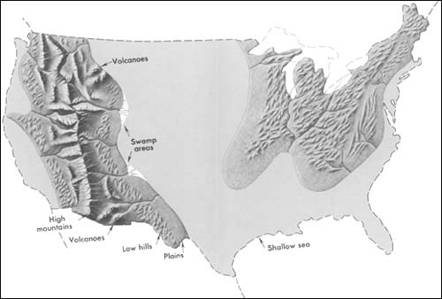
English: Generalized geographic map of the United States in Late Cretaceous time. Note: Eighty million years ago, during the Age of Dinosaurs, the geography of North America was very different from that of today. Mountain ranges have changed considerably since this, the Cretaceous Period. The Appalachian Mountains were probably lower and less conspicuous as a source of sediment than they are today; apparently they supplied appreciable amounts of coarse sediment only in the Southeast (Tennessee, Alabama, Mississippi, and Georgia). The Rocky Mountains, as they are today, did not exist; instead a giant trough in which marine sediment slowly accumulated occupied this part of the West. Shallow, warm inland seas covered large portions of the Southern and Western United States, as shown on the map. Large portions of California were under water, and in eastern California, Nevada, Arizona, Idaho, eastern Oregon, Washington, and Alberta, a belt of the Earth's crust slowly rose to form a new mountain range. Details from this vast highland extended eastward into Utah, Wyoming, Colorado, and New Mexico. Still farther east, Kansas, Nebraska, and adjacent States to the north and south were covered by warm, extensive, but shallow seas in which beds of limestone slowly formed. The Cretaceous Period marked the last extensive covering of the North American continent by the sea. Since then, sea level has dropped and the continent has gradually emerged to its present size and shape. |
| التاريخ | |
| المصدر | http://pubs.usgs.gov/gip/continents/cretaceous.jpg |
| المؤلف | USGS |
ترخيص
تقع هذه الصُّورة في النِّطاق العامّ لأنَّها تحتوي مواد حصريَّة مِن إِنتاج هيئة المساحة الجيولوجيَّة الأمريكيَّة في وزارة الداخلية في الولايات المُتحدة الأمريكيَّة. للمزيد مِن المعلومات انظر سياسية حقوق التَّأليف والنَّشر في موقع هيئة المساحة الجيولوجيَّة الأمريكيَّة الرسميَّة.
|
سجلُّ الرَّفع الأصيل
صفحة الوصف الأصلية كانت هنا، تشير جميع أسماء المستخدمين التالية إلى en.wikipedia.
- 2005-04-15 02:44 SEWilco 500×338× (20737 bytes) Generalized geographic map of the [[United States]] in [[Late Cretaceous]] time. Eighty million years ago, during the Age of Dinosaurs, the geography of [[North America]] was very different from that of today. Mountain ranges have changed considerably si
تاريخ الملف
اضغط على زمن/تاريخ لرؤية الملف كما بدا في هذا الزمن.
| زمن/تاريخ | صورة مصغرة | الأبعاد | مستخدم | تعليق | |
|---|---|---|---|---|---|
| حالي | 05:03، 17 يونيو 2011 | | 500 × 338 (20 كيلوبايت) | File Upload Bot (Magnus Manske) | {{BotMoveToCommons|en.wikipedia|year={{subst:CURRENTYEAR}}|month={{subst:CURRENTMONTHNAME}}|day={{subst:CURRENTDAY}}}} {{Information |Description={{en|Generalized geographic map of the en:United States in en:Late Cretaceous time. Eighty mill |
استخدام الملف
الصفحة التالية تستخدم هذا الملف:
الاستخدام العالمي للملف
الويكيات الأخرى التالية تستخدم هذا الملف:
- الاستخدام في en.wikipedia.org
- الاستخدام في sh.wikipedia.org