
ملف:Ancient tamilakam ports.png
حجم هذه المعاينة: 607 × 600 بكسل. الأبعاد الأخرى: 243 × 240 بكسل | 486 × 480 بكسل | 777 × 768 بكسل | 1٬036 × 1٬024 بكسل | 2٬073 × 2٬048 بكسل | 4٬984 × 4٬925 بكسل.
الملف الأصلي (4٬984 × 4٬925 بكسل حجم الملف: 9 ميجابايت، نوع MIME: image/png)
| هذا ملف من ويكيميديا كومنز. معلومات من صفحة وصفه مبينة في الأسفل. كومنز مستودع ملفات ميديا ذو رخصة حرة. |
ملخص
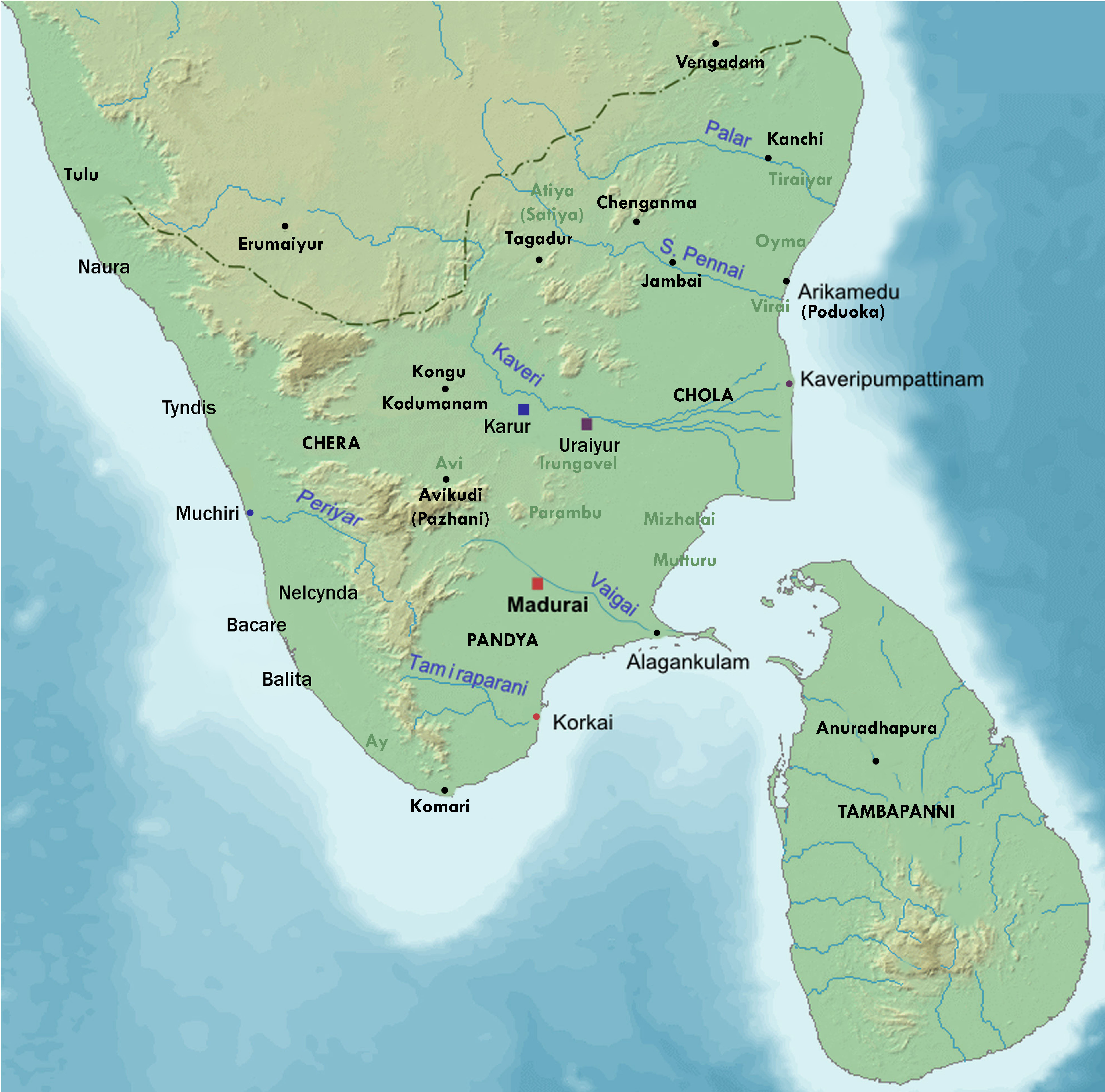
| الوصف | Map showing the important port cities of ancient Tamil country and its approximate northern boundary |
| التاريخ | |
| المصدر |
Source of map: http://www2.demis.nl/mapserver/mapper.asp (mention : "Disclaimer: With this statement DEMIS BV grants you permission to freely copy the PNG images returned by our server and use them for your own purposes, including web pages. We would appreciate a reference to our server but such a reference is not required, nor do we take responsibility for the accuracy or quality of the maps". at http://www2.demis.nl/mapserver/DataSrc.htm) Modified by me using Inkscape. |
| المؤلف | Lotlil |
ترخيص
| وضع -I, Lotlil-، وهو المؤلف، هذا العمل في النِّطاق العامِّ. يسري ذلك في كل أرجاء العالم. في بعض البلدان، قد يكون هذا التَّرخيص غيرَ مُمكنٍ قانونيَّاً، في هذه الحالة: يمنح I, Lotlil الجميع حق استخدام هذا العمل لأي غرض دون أي شرط ما لم يفرض القانون شروطًا إضافية. |
تاريخ الملف
اضغط على زمن/تاريخ لرؤية الملف كما بدا في هذا الزمن.
| زمن/تاريخ | صورة مصغرة | الأبعاد | مستخدم | تعليق | |
|---|---|---|---|---|---|
| حالي | 07:24، 29 نوفمبر 2019 | | 4٬984 × 4٬925 (9 ميجابايت) | StephenPaa | Added more locations |
| 09:41، 29 أغسطس 2019 |  | 2٬000 × 2٬000 (2٫61 ميجابايت) | StephenPaa | Added Karur | |
| 08:57، 29 أغسطس 2019 |  | 2٬000 × 2٬000 (2٫61 ميجابايت) | StephenPaa | Corrected the colour of some ports and the Chera country | |
| 04:49، 7 أغسطس 2007 |  | 800 × 800 (385 كيلوبايت) | Lotlil | {{Information |Description=Map showing the important port cities of ancient Tamil country and its approximate northern boundary |Source=Source of map: http://www2.demis.nl/mapserver/mapper.asp (mention : "Disclaimer: With this statement DEMIS BV grants yo | |
| 04:41، 7 أغسطس 2007 |  | 800 × 800 (385 كيلوبايت) | Lotlil | {{Information |Description=Map showing the important port cities of ancient Tamil country and its approximate northern boundary |Source=Source of map: http://www2.demis.nl/mapserver/mapper.asp (mention : "Disclaimer: With this statement DEMIS BV grants yo |
استخدام الملف
الصفحة التالية تستخدم هذا الملف:
الاستخدام العالمي للملف
الويكيات الأخرى التالية تستخدم هذا الملف:
- الاستخدام في de.wikipedia.org
- الاستخدام في en.wikipedia.org
- الاستخدام في hu.wikipedia.org
- الاستخدام في ko.wikipedia.org