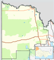
ملف:Australia Victoria Mildura Rural City location map.svg
المظهر

حجم معاينة PNG لذلك الملف ذي الامتداد SVG: 533 × 593 بكسل. الأبعاد الأخرى: 216 × 240 بكسل | 431 × 480 بكسل | 690 × 768 بكسل | 920 × 1٬024 بكسل | 1٬841 × 2٬048 بكسل.
الملف الأصلي (ملف SVG، أبعاده 533 × 593 بكسل، حجم الملف: 601 كيلوبايت)
تاريخ الملف
اضغط على زمن/تاريخ لرؤية الملف كما بدا في هذا الزمن.
| زمن/تاريخ | صورة مصغرة | الأبعاد | مستخدم | تعليق | |
|---|---|---|---|---|---|
| حالي | 17:48، 17 فبراير 2011 |  | 533 × 593 (601 كيلوبايت) | Cassowary | {{Information |Description ={{en|1=Blank map of w:Mildura Rural City, Victoria, Australia, with the following information shown: * LGA boundaries * Coastline, lakes and rivers * Roads and railways * Urban areas * Parks Geographic limits: * North: |
استخدام الملف
الصفحة التالية تستخدم هذا الملف:
الاستخدام العالمي للملف
الويكيات الأخرى التالية تستخدم هذا الملف:
- الاستخدام في ceb.wikipedia.org
- الاستخدام في en.wikipedia.org
- Rural City of Mildura
- Mildura
- Merbein
- Nangiloc, Victoria
- Red Cliffs, Victoria
- Murrayville, Victoria
- Underbool
- Ouyen
- Werrimull
- Yelta, Victoria
- Birdwoodton, Victoria
- Irymple, Victoria
- Meringur
- Patchewollock
- Colignan, Victoria
- Cardross, Victoria
- Boinka, Victoria
- Linga, Victoria
- Panitya, Victoria
- Carina, Victoria
- Manya, Victoria
- Iraak, Victoria
- Merrinee, Victoria
- Karween, Victoria
- Morkalla, Victoria
- Cowangie
- Tutye, Victoria
- Torrita, Victoria
- Walpeup
- Galah, Victoria
- Koorlong, Victoria
- Cullulleraine
- Hattah
- Carwarp, Victoria
- Nichols Point, Victoria
- Cabarita, Victoria
- Tempy, Victoria
- Merbein South
- Mittyack, Victoria
- Neds Corner, Victoria
- Lindsay Point, Victoria
- Merbein West, Victoria
- Wargan, Victoria
- Kulwin, Victoria
- Template:Towns in the Rural City of Mildura
- Berrook, Victoria
- Module:Location map/data/Australia Victoria Rural City of Mildura/doc
- Big Desert, Victoria
- Murray-Sunset, Victoria
اعرض المزيد من الاستخدام العام لهذا الملف.

