
ملف:Australia Victoria Warrnambool City location map.svg

حجم معاينة PNG لذلك الملف ذي الامتداد SVG: 534 × 346 بكسل. الأبعاد الأخرى: 320 × 207 بكسل | 640 × 415 بكسل | 1٬024 × 663 بكسل | 1٬280 × 829 بكسل | 2٬560 × 1٬659 بكسل.
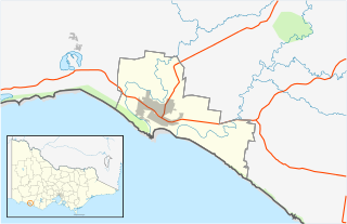
الملف الأصلي (ملف SVG، أبعاده 534 × 346 بكسل، حجم الملف: 396 كيلوبايت)
| هذا ملف من ويكيميديا كومنز. معلومات من صفحة وصفه مبينة في الأسفل. كومنز مستودع ملفات ميديا ذو رخصة حرة. |
| الوصف |
English: Blank map of w:Warrnambool City, Victoria, Australia, with the following information shown:
Geographic limits:
|
||
| المصدر | عمل شخصي + VicMap Lite | ||
| المؤلف | Cassowary |

تاريخ الملف
اضغط على زمن/تاريخ لرؤية الملف كما بدا في هذا الزمن.
| زمن/تاريخ | صورة مصغرة | الأبعاد | مستخدم | تعليق | |
|---|---|---|---|---|---|
| حالي | 14:04، 18 فبراير 2011 | | 534 × 346 (396 كيلوبايت) | Cassowary | {{Information |Description ={{en|1=Blank map of w:Warrnambool City, Victoria, Australia, with the following information shown: * LGA boundaries * Coastline, lakes and rivers * Roads and railways * Urban areas * Parks Geographic limits: * North: 38 |
استخدام الملف
الصفحة التالية تستخدم هذا الملف:
الاستخدام العالمي للملف
الويكيات الأخرى التالية تستخدم هذا الملف:
- الاستخدام في ceb.wikipedia.org
- الاستخدام في en.wikipedia.org
- City of Warrnambool
- Warrnambool
- Allansford, Victoria
- Woodford, Victoria
- Bushfield, Victoria
- Template:Towns in the City of Warrnambool
- Dennington, Victoria
- Module:Location map/data/Australia Victoria City of Warrnambool/doc
- Module:Location map/data/Australia Victoria City of Warrnambool
- User:Viatori/sandbox
- Yangery
- Illowa
- User:ThylacineHunter/LGA
- الاستخدام في fa.wikipedia.org
- الاستخدام في kn.wikipedia.org
- الاستخدام في si.wikipedia.org
- الاستخدام في tr.wikipedia.org
- الاستخدام في uz.wikipedia.org
- الاستخدام في war.wikipedia.org