
ملف:Carta Hydrographica y Chorographica de la Yslas Filipinas MANILA, 1734.jpg

حجم هذه المعاينة: 641 × 599 بكسل. الأبعاد الأخرى: 257 × 240 بكسل | 513 × 480 بكسل | 821 × 768 بكسل | 1٬095 × 1٬024 بكسل | 2٬000 × 1٬870 بكسل.
الملف الأصلي (2٬000 × 1٬870 بكسل حجم الملف: 2٫09 ميجابايت، نوع MIME: image/jpeg)
| هذا ملف من ويكيميديا كومنز. معلومات من صفحة وصفه مبينة في الأسفل. كومنز مستودع ملفات ميديا ذو رخصة حرة. |
ملخص
| الوصف |
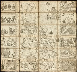
English: This magnificent map of the Philippine archipelago, drawn by the Jesuit Father Pedro Murillo Velarde (1696–1753) and published in Manila in 1734, is the first and most important scientific map of the Philippines. The Philippines were at that time a vital part of the Spanish Empire, and the map shows the maritime routes from Manila to Spain and to New Spain (Mexico and other Spanish territory in the New World), with captions. In the upper margin stands a great cartouche with the title of the map, crowned by the Spanish royal coat of arms flanked each side by an angel with a trumpet, from which an inscription unfurls. The map is not only of great interest from the geographic point of view, but also as an ethnographic document. It is flanked by twelve engravings, six on each side, eight of which depict different ethnic groups living in the archipelago and four of which are cartographic descriptions of particular cities or islands. According to the labels, the engravings on the left show: Sangleyes (Chinese Philippinos) or Chinese; Kaffirs (a derogatory term for non-Muslims), a Camarin (from the Manila area), and a Lascar (from the Indian subcontinent, a British Raj term); mestizos, a Mardica (of Portuguese extraction), and a Japanese; and two local maps—one of Samboagan (a city on Mindanao), and the other of the port of Cavite. On the right side are: various people in typical dress; three men seated, an Armenian, a Mughal, and a Malabar (from an Indian textile city); an urban scene with various peoples; a rural scene with representations of domestic and wild animals; a map of the island of Guajan (meaning Guam); and a map of Manila.
Ethnic groups; Nautical charts |
| التاريخ | |
| المصدر | https://www.wdl.org/en/item/10089/ |
| المؤلف |
Cartographer: Murillo Velarde, Pedro, 1696-1753 Engraver: Bagay, Nicolás de la Cruz, 1701-1771 |
ترخيص
|
هذا العمل يقع في النَّطاق العامّ في بلد المنشأ وفي البلدان الأخرى والمناطق التي تمتدُّ فيها مدة حقوق التَّأليف والنشر لتغطي زمن حياة المُؤلِّف و 50 سنةً بعد وفاته أو أقل من ذلك. يقع هذ العمل في النَّطاق العامِّ في الولايات المُتحدة الأمريكيَّة لأنَّه نُشِرَ (أو سُجِّل لدى مكتب الولايات المُتحدة لحقوق التَّأليف والنَّشر) قبل ١ يناير ١٩٢٩. |
تاريخ الملف
اضغط على زمن/تاريخ لرؤية الملف كما بدا في هذا الزمن.
| زمن/تاريخ | صورة مصغرة | الأبعاد | مستخدم | تعليق | |
|---|---|---|---|---|---|
| حالي | 18:23، 9 نوفمبر 2018 | | 2٬000 × 1٬870 (2٫09 ميجابايت) | Obsidian Soul | User created page with UploadWizard |
استخدام الملف
الصفحة التالية تستخدم هذا الملف:
الاستخدام العالمي للملف
الويكيات الأخرى التالية تستخدم هذا الملف:
- الاستخدام في en.wikipedia.org
- الاستخدام في en.wikiquote.org
- الاستخدام في es.wikipedia.org
- الاستخدام في www.wikidata.org