
ملف:Colombia.A2004117.1535.250m.jpg

الملف الأصلي (1٬500 × 2٬000 بكسل حجم الملف: 898 كيلوبايت، نوع MIME: image/jpeg)
| هذا ملف من ويكيميديا كومنز. معلومات من صفحة وصفه مبينة في الأسفل. كومنز مستودع ملفات ميديا ذو رخصة حرة. |
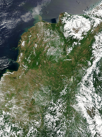
Floods in Colombia, April 2004.
Marshes and wetlands line Colombia’s Magdalena River in its course north from the Andes Mountains to the Caribbean Sea. The wetlands, which form black and blue patches along the river in the false color image, are important for birds arriving from the north for the winter. The area had received heavy rain which triggered floods and landslides. Though the floods aren't visible in these images, the tan plume of sediment flowing into the Caribbean from the Magdalena River in the true-color image may be a result of high, fast-moving waters carrying extra mud into the sea. This true and false color image pair was captured by the Moderate Resolution Imaging Spectroradiometer (MODIS) on the Aqua satellite on April 26, 2004.
http://visibleearth.nasa.gov/view_rec.php?id=6531 نسخة مؤرشفة at the Wayback Machine
| يقع هذا العمل في النِّطاق العامّ في الولايات المُتحدة الأمريكيَّة لأَنَّه عملٌ خالِصٌ من إِنتاج وكالة الفضاء الأمريكيَّة. تنصُ حقوق التَّأليف والنَّشر الخاصَّة بوكالة الفضاء الأمريكيَّة على أنَّ "أعمال الوكالة غير مَحميَّة بحقوق التَّأليف والنَّشر ما لم يُذكر خلافُ ذلك". لمزيدٍ من المعلومات انظر القالِب {{PD-USGov}} وصفحة حقوق التَّأليف والنَّشر الخاصَّة بالوكالة وصفحة سياسة الصُّور الخاصَّة بمُختبر الدَّفع النَّفَّاث. | ||
 |
تنبيهات:
|
تاريخ الملف
اضغط على زمن/تاريخ لرؤية الملف كما بدا في هذا الزمن.
| زمن/تاريخ | صورة مصغرة | الأبعاد | مستخدم | تعليق | |
|---|---|---|---|---|---|
| حالي | 19:36، 27 أكتوبر 2005 | | 1٬500 × 2٬000 (898 كيلوبايت) | Brian0918 | Floods in Colombia, April 2004. Marshes and wetlands line Colombia’s Magdalena River in its course north from the Andes Mountains to the Caribbean Sea. The wetlands, which form black and blue patches along the river in the false color image, are import |
استخدام الملف
الصفحة التالية تستخدم هذا الملف:
الاستخدام العالمي للملف
الويكيات الأخرى التالية تستخدم هذا الملف:
- الاستخدام في af.wikipedia.org
- الاستخدام في el.wikipedia.org
- الاستخدام في en.wikipedia.org
- الاستخدام في fr.wikipedia.org
- الاستخدام في ms.wikipedia.org
- الاستخدام في ru.wikipedia.org
- الاستخدام في sl.wikipedia.org
- الاستخدام في uk.wikipedia.org
- الاستخدام في vi.wikipedia.org