
ملف:East of England districts 2011 map.svg

حجم معاينة PNG لذلك الملف ذي الامتداد SVG: 573 × 600 بكسل. الأبعاد الأخرى: 229 × 240 بكسل | 459 × 480 بكسل | 734 × 768 بكسل | 979 × 1٬024 بكسل | 1٬957 × 2٬048 بكسل | 1٬210 × 1٬266 بكسل.
الملف الأصلي (ملف SVG، أبعاده 1٬210 × 1٬266 بكسل، حجم الملف: 2٫14 ميجابايت)
| هذا ملف من ويكيميديا كومنز. معلومات من صفحة وصفه مبينة في الأسفل. كومنز مستودع ملفات ميديا ذو رخصة حرة. |
ملخص
| الوصف |
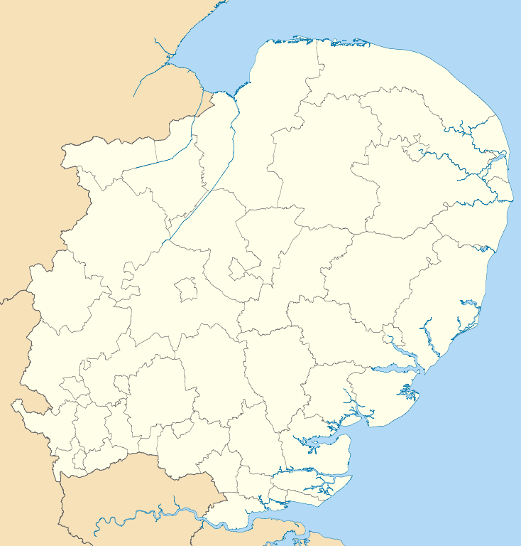
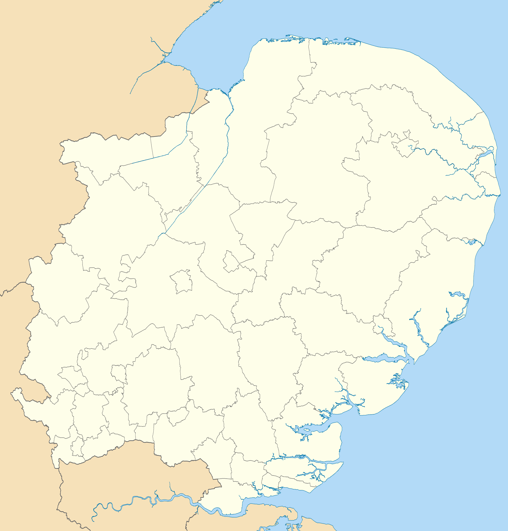
Map of the East of England region showing the administrative districts. Equirectangular map projection on WGS 84 datum, with N/S stretched 160% Geographic limits:
|
| التاريخ | |
| المصدر |
|
| المؤلف | Nilfanion, created using Ordnance Survey data |
| إصدارات أخرى |
أَعمالٌ مُشتقَّة مِن هذا الملفِّ: |
ترخيص
أنا، صاحب حقوق التأليف والنشر لهذا العمل، أنشر هذا العمل تحت الرخص التالية:
هذا الملفُّ مُرخَّص بموجب رخصة المشاع الإبداعي نسبة المُصنَّف إِلى مُؤَلِّفه - المشاركة بالمثل 3.0 العامة
- يحقُّ لك:
- مشاركة العمل – نسخ العمل وتوزيعه وبثُّه
- إعادة إنتاج العمل – تعديل العمل
- حسب الشروط التالية:
- نسب العمل إلى مُؤَلِّفه – يلزم نسب العمل إلى مُؤَلِّفه بشكل مناسب وتوفير رابط للرخصة وتحديد ما إذا أجريت تغييرات. بالإمكان القيام بذلك بأية طريقة معقولة، ولكن ليس بأية طريقة تشير إلى أن المرخِّص يوافقك على الاستعمال.
- الإلزام بترخيص المُشتقات بالمثل – إذا أعدت إنتاج المواد أو غيرت فيها، فيلزم أن تنشر مساهماتك المُشتقَّة عن الأصل تحت ترخيص الأصل نفسه أو تحت ترخيص مُتوافِقٍ معه.

|
يسمح نسخ وتوزيع و/أو تعديل هذه الوثيقة تحت شروط رخصة جنو للوثائق الحرة، الإصدار 1.2 أو أي إصدار لاحق تنشره مؤسسة البرمجيات الحرة؛ دون أقسام ثابتة ودون نصوص أغلفة أمامية ودون نصوص أغلفة خلفية. نسخة من الرخصة تم تضمينها في القسم المسمى GNU Free Documentation License. |
لك أن تختار الرخصة التي تناسبك.
تاريخ الملف
اضغط على زمن/تاريخ لرؤية الملف كما بدا في هذا الزمن.
| زمن/تاريخ | صورة مصغرة | الأبعاد | مستخدم | تعليق | |
|---|---|---|---|---|---|
| حالي | 18:51، 1 مايو 2011 | | 1٬210 × 1٬266 (2٫14 ميجابايت) | Nilfanion | {{Information |Description=Map of the East of England region showing the administrative districts. Equirectangular map projection on WGS 84 datum, with N/S stretched 160% Geographic limits: *West: 0.8W *East: 1.8E *North: 53.1N *So |
استخدام الملف
الصفحتان التاليتان تستخدمان هذا الملف:
الاستخدام العالمي للملف
الويكيات الأخرى التالية تستخدم هذا الملف:
- الاستخدام في en.wikipedia.org
- Cambridge
- East of England
- Luton
- Ipswich
- Thurrock
- Norwich
- Huntingdonshire
- Southend-on-Sea
- Welwyn Hatfield
- Stevenage
- Harlow
- Watford
- King's Lynn and West Norfolk
- St Albans City and District
- City of Peterborough
- South Cambridgeshire
- East Cambridgeshire
- Fenland District
- Castle Point
- Uttlesford
- Tendring District
- Hertsmere
- Borough of Broxbourne
- East Hertfordshire
- North Hertfordshire
- Dacorum
- South Norfolk
- Broadland
- Breckland District
- North Norfolk
- Mid Suffolk
- Babergh District
- Template:East of England
- Borough of Bedford
- Braintree District
- City of Colchester
- Epping Forest District
- Borough of Basildon
- Maldon District
- Borough of Great Yarmouth
- Rochford District
- City of Chelmsford
- Borough of Brentwood
- Eastern Counties Football League
- Three Rivers District
- User:Mwphoto/Watford
- User:Phildav76/Regional templates
- Old Harlow
- 2006–07 Isthmian League
- Central Bedfordshire
اعرض المزيد من الاستخدام العام لهذا الملف.