
ملف:Emily 2005-07-16 1545Z (cropped).jpg

حجم هذه المعاينة: 600 × 600 بكسل. الأبعاد الأخرى: 240 × 240 بكسل | 480 × 480 بكسل | 768 × 768 بكسل | 1٬024 × 1٬024 بكسل | 2٬048 × 2٬048 بكسل | 4٬000 × 4٬000 بكسل.
الملف الأصلي (4٬000 × 4٬000 بكسل حجم الملف: 2٫26 ميجابايت، نوع MIME: image/jpeg)
| هذا ملف من ويكيميديا كومنز. معلومات من صفحة وصفه مبينة في الأسفل. كومنز مستودع ملفات ميديا ذو رخصة حرة. |
ملخص
| الوصف |
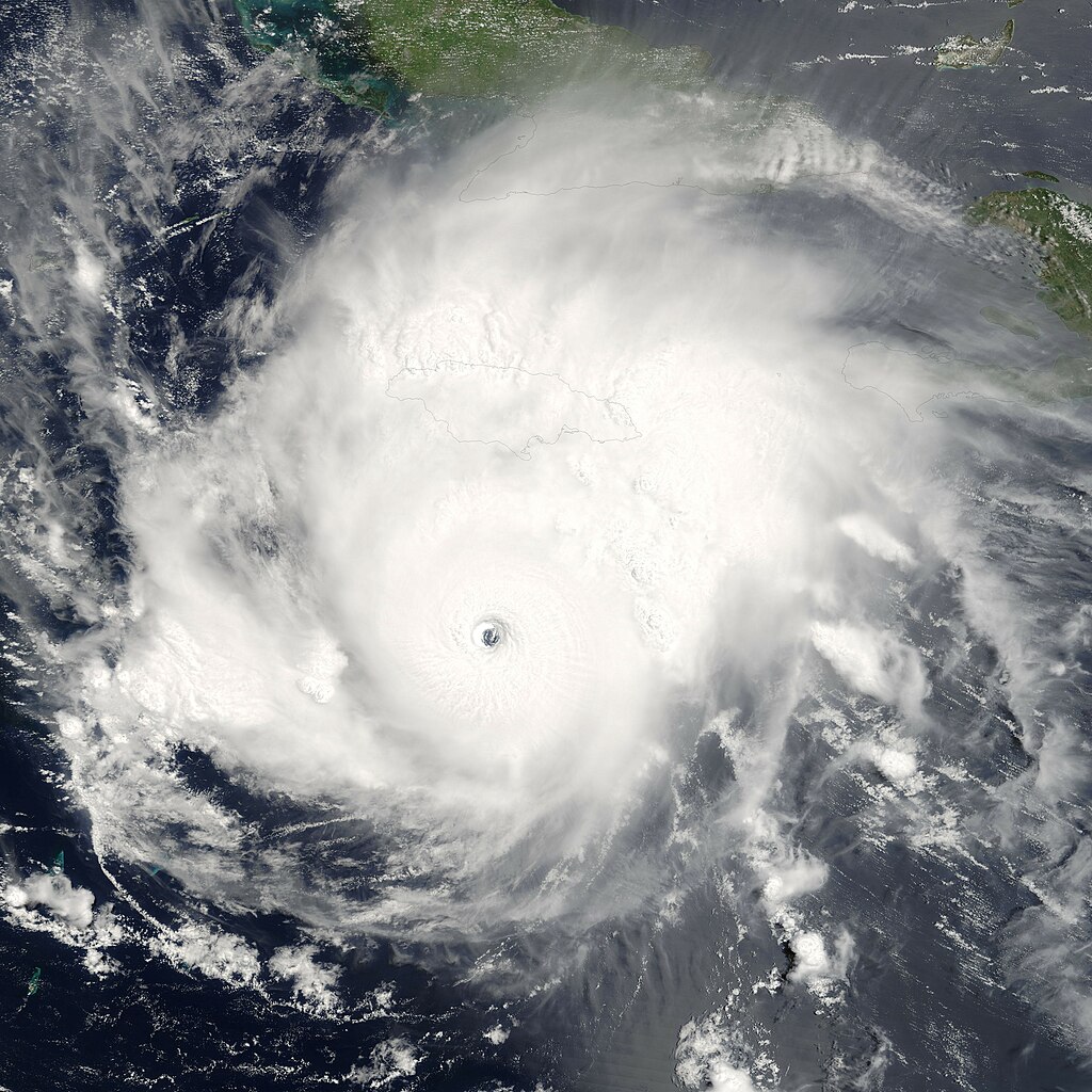
Hurricane Emily was spinning through the Caribbean south of Jamacia on July 16, 2005, when the Moderate Resolution Imaging Spectroradiometer (MODIS) on the Terra satellite captured this image at 15:45 UTC (11:45 a.m. Eastern Daylight Time). At this time, Emily was a well-developed hurricane with winds over 230 kilometers an hour (125 knots) and gusts as high as 285 km/hr (155 knots). As shown in this satellite image, the storm is passing roughly east to west well south of Jamaica (around 160 kilometers, or 100 miles), but the heavy rains in the storm�s outer bands fell on an already sodden island still recovering from Hurricane Dennis, which similarly glanced the island on July 7. Emily�s rains caused flooding, which has resulted in four deaths on the island. Tourists in the Yucatan Peninsula are being evacuated from resort areas and beaches as the hurricane continues on track to make landfall there during the morning of July 18, 2005. |
|||||
| التاريخ | ||||||
| المصدر | http://earthobservatory.nasa.gov/NaturalHazards/natural_hazards_v2.php3?img_id=12967 | |||||
| المؤلف | NASA image provided courtesy of Jeff Schmaltz, MODIS Rapid Response team. | |||||
| الترخيص (إعادة استخدام هذا الملف) |
|
|||||
| إصدارات أخرى | Image:Hurricane Emily 16 july 2005 1545Z.jpg |

.jpg)
تاريخ الملف
اضغط على زمن/تاريخ لرؤية الملف كما بدا في هذا الزمن.
| زمن/تاريخ | صورة مصغرة | الأبعاد | مستخدم | تعليق | |
|---|---|---|---|---|---|
| حالي | 19:32، 13 أغسطس 2006 | | 4٬000 × 4٬000 (2٫26 ميجابايت) | Nilfanion | {{Information| |Description= == Summary == {{Information |Description=Hurricane Emily was spinning through the en:Caribbean south of en:Jamaica on en:July 16, en:2005, when the Moderate Resolution Imaging |
استخدام الملف
الصفحة التالية تستخدم هذا الملف:
الاستخدام العالمي للملف
الويكيات الأخرى التالية تستخدم هذا الملف:
- الاستخدام في ca.wikipedia.org
- الاستخدام في de.wikipedia.org
- الاستخدام في en.wikipedia.org
- Portal:Tropical cyclones/Selected image/3
- User:Cavin165
- User:Omni ND/Good Pictures
- Portal talk:Tropical cyclones/Selected picture
- User:DaBloonsplayer
- Wikipedia:Featured picture candidates/January-2012
- Wikipedia:Featured picture candidates/Hurricane Emily
- User:SuperNascar 1991
- Portal:Tropical cyclones/Selected image
- الاستخدام في eu.wikipedia.org
- الاستخدام في fr.wikipedia.org
- الاستخدام في pt.wikipedia.org
- الاستخدام في simple.wikipedia.org
- الاستخدام في zh.wikipedia.org
.jpg)