
ملف:Great Lakes bathymetry map.png
الملف الأصلي (1٬024 × 731 بكسل حجم الملف: 1٫34 ميجابايت، نوع MIME: image/png)
| هذا ملف من ويكيميديا كومنز. معلومات من صفحة وصفه مبينة في الأسفل. كومنز مستودع ملفات ميديا ذو رخصة حرة. |
ملخص
| الوصف |
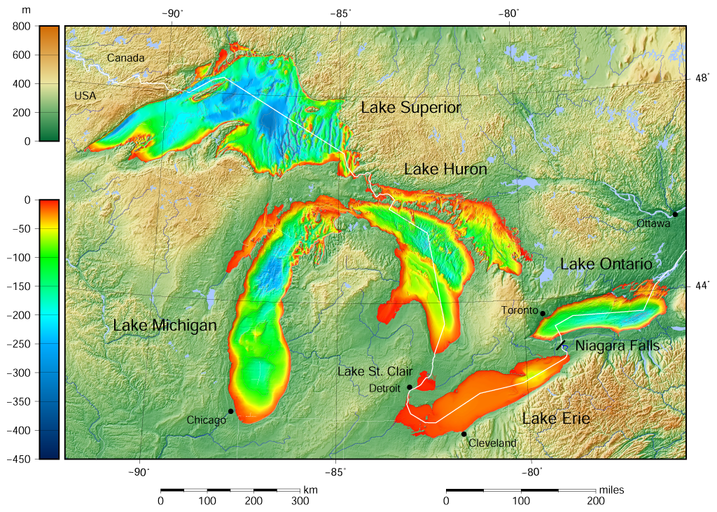
English: Great Lakes bathymetry and surrounding area shaded relief map. Lakes are contoured with interval 100 m. Lake Superior is incomplete. |
| التاريخ | |
| المصدر |
Own work using: the following Public Domain datasets (grids):
The color palette of the depth scale was made to be more or less similar to the color palettes used on the NGDC Great Lakes maps. .هذا الرسم المتجهي أُنشئ بواسطة GMT |
| المؤلف | Darekk2 using the Great Lakes Bathymetry and GLOBE tiles |
| إصدارات أخرى |
|

ترخيص
Attribution (in addition to the author of this map):
The NGDC in it's copyright notice says:
As required by 17 U.S.C. 403, third parties producing copyrighted works consisting predominantly of the material produced by U.S. government agencies must provide notice with such work(s) identifying the U.S. Government material incorporated and stating that such material is not subject to copyright protection within the United States. (...)
(for credits see the Source section).
and Great Lakes Bathymetry and GLOBE
(see above and the Source section)
- يحقُّ لك:
- مشاركة العمل – نسخ العمل وتوزيعه وبثُّه
- إعادة إنتاج العمل – تعديل العمل
- حسب الشروط التالية:
- نسب العمل إلى مُؤَلِّفه – يلزم نسب العمل إلى مُؤَلِّفه بشكل مناسب وتوفير رابط للرخصة وتحديد ما إذا أجريت تغييرات. بالإمكان القيام بذلك بأية طريقة معقولة، ولكن ليس بأية طريقة تشير إلى أن المرخِّص يوافقك على الاستعمال.
- الإلزام بترخيص المُشتقات بالمثل – إذا أعدت إنتاج المواد أو غيرت فيها، فيلزم أن تنشر مساهماتك المُشتقَّة عن الأصل تحت ترخيص الأصل نفسه أو تحت ترخيص مُتوافِقٍ معه.
تاريخ الملف
اضغط على زمن/تاريخ لرؤية الملف كما بدا في هذا الزمن.
| زمن/تاريخ | صورة مصغرة | الأبعاد | مستخدم | تعليق | |
|---|---|---|---|---|---|
| حالي | 15:46، 9 مايو 2015 | | 1٬024 × 731 (1٫34 ميجابايت) | Darekk2 | more accurate shorelines, the lakes tiles better assembled, added Canada, USA and Lake St. Clair labels, moved Detroit label, Michigan Lake - retouched western part of Green Bay |
| 10:03، 25 مارس 2015 |  | 1٬024 × 731 (1٫34 ميجابايت) | Darekk2 | changed illumination for shaded relief | |
| 01:29، 25 مارس 2015 |  | 1٬024 × 731 (1٫33 ميجابايت) | Darekk2 | changed palette a little | |
| 20:21، 24 مارس 2015 |  | 1٬024 × 731 (1٫61 ميجابايت) | Darekk2 | User created page with UploadWizard |
استخدام الملف
الصفحة التالية تستخدم هذا الملف:
الاستخدام العالمي للملف
الويكيات الأخرى التالية تستخدم هذا الملف:
- الاستخدام في crh.wikipedia.org
- الاستخدام في en.wikipedia.org
- الاستخدام في fi.wikipedia.org
- الاستخدام في ja.wikipedia.org
- الاستخدام في nl.wikipedia.org
- الاستخدام في sr.wikipedia.org
- الاستخدام في tt.wikipedia.org
- الاستخدام في uk.wikipedia.org
- الاستخدام في vep.wikipedia.org
- الاستخدام في www.wikidata.org
- الاستخدام في zh-yue.wikipedia.org