
ملف:Hazesmoke Gangeticbasin.jpg
الملف الأصلي (975 × 800 بكسل حجم الملف: 213 كيلوبايت، نوع MIME: image/jpeg)
| هذا ملف من ويكيميديا كومنز. معلومات من صفحة وصفه مبينة في الأسفل. كومنز مستودع ملفات ميديا ذو رخصة حرة. |
ملخص
Source:http://climate.gsfc.nasa.gov/viewImage.php?id=110 نسخة مؤرشفة at the Wayback Machine
Updated Link to Source:https://earthobservatory.nasa.gov/images/5103/haze-and-smog-over-india
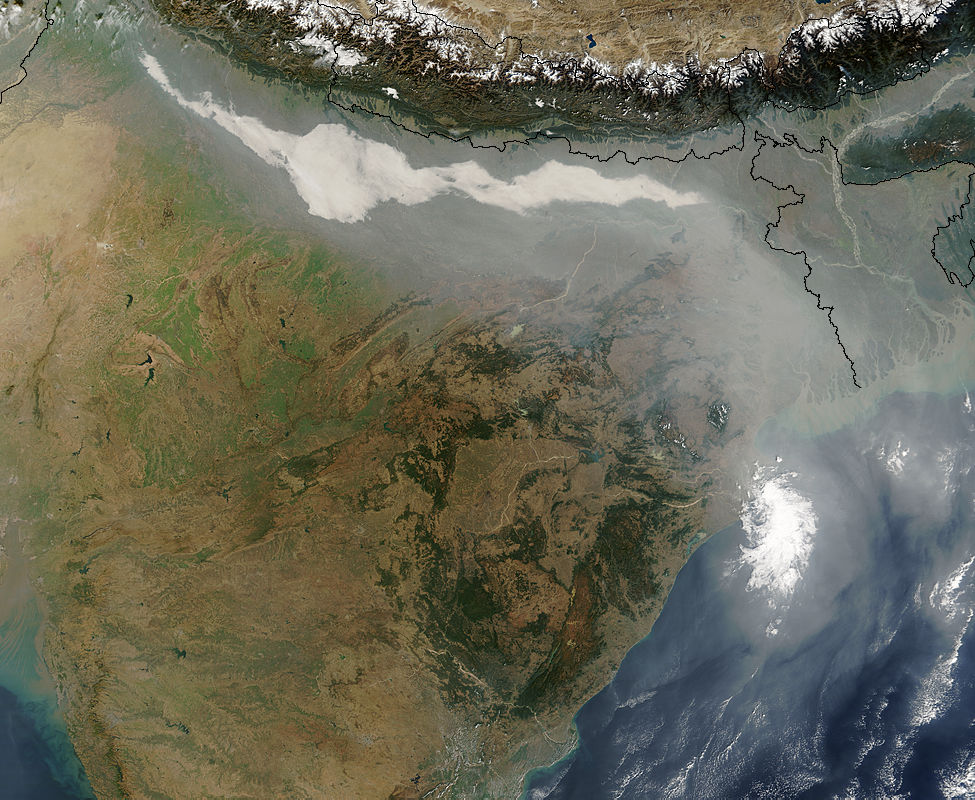
Description: This image, taken by Terra/MODIS instrument on December 17, 2004 shows thick haze and smoke along the Ganges Basin in northern India. Major sources of aerosols in this area are believed to be smoke from biomass burning in the northwest part of India, and air pollution from large cities in northern India. Dust from deserts in Pakistan and the Middle East may also contribute to the mix of aerosols. The average wind is directed to blow aerosols along the steep hillside of the Tibetan Plateau, to the eastern part of India and the Bay of Bengal.
Dust and black carbon, which are blown towards higher altitudes by winds at the southern slope of the Himalayas, can absorb shortwave radiation and form elevated heat sources over the Tibetan Plateau. The net atmospheric heating due to aerosol absorption causes the air to warm and rise, increasing the concentration of moisture in the mid-troposphere, and providing a positive feedback to the aerosol heating. A recent modeling study shows that upper tropospheric heating over the Tibetan Plateau induced by absorbing aerosols in late spring and early summer can induce an early onset and subsequent intensification of the Indian summer monsoon.
(Submitted by William K-M Lau)
ترخيص
| يقع هذا العمل في النِّطاق العامّ في الولايات المُتحدة الأمريكيَّة لأَنَّه عملٌ خالِصٌ من إِنتاج وكالة الفضاء الأمريكيَّة. تنصُ حقوق التَّأليف والنَّشر الخاصَّة بوكالة الفضاء الأمريكيَّة على أنَّ "أعمال الوكالة غير مَحميَّة بحقوق التَّأليف والنَّشر ما لم يُذكر خلافُ ذلك". لمزيدٍ من المعلومات انظر القالِب {{PD-USGov}} وصفحة حقوق التَّأليف والنَّشر الخاصَّة بالوكالة وصفحة سياسة الصُّور الخاصَّة بمُختبر الدَّفع النَّفَّاث. | ||
 |
تنبيهات:
|
تاريخ الملف
اضغط على زمن/تاريخ لرؤية الملف كما بدا في هذا الزمن.
| زمن/تاريخ | صورة مصغرة | الأبعاد | مستخدم | تعليق | |
|---|---|---|---|---|---|
| حالي | 06:13، 17 أبريل 2007 | | 975 × 800 (213 كيلوبايت) | Dwaipayanc | Source:http://climate.gsfc.nasa.gov/viewImage.php?id=110 Description: This image, taken by Terra/MODIS instrument on December 17, 2004 shows thick haze and smoke along the Ganges Basin in northern India. Major sources of aerosols in this area are believe |
استخدام الملف
الصفحة التالية تستخدم هذا الملف:
الاستخدام العالمي للملف
الويكيات الأخرى التالية تستخدم هذا الملف:
- الاستخدام في en.wikipedia.org
- الاستخدام في fr.wikiversity.org
- الاستخدام في hi.wikipedia.org
- الاستخدام في ta.wikipedia.org
- الاستخدام في th.wikipedia.org
- الاستخدام في zh.wikipedia.org