انتقل إلى المحتوى

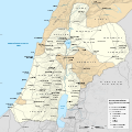
ملف:Herodian Kingdom political map.svg

محتويات الصفحة غير مدعومة بلغات أخرى.
من ويكيبيديا، الموسوعة الحرة

الملف الأصلي(ملف SVG، أبعاده 1٬350 × 1٬350 بكسل، حجم الملف: 8٫89 ميجابايت)

ملخص

العنوان
Herodian Kingdom of Judea at its greatest extent
الوصف
English: In 32 BCE Octavian defeated Mark Antony at Actium, and Herod, having made his peace with the victor, was confirmed as King, and had Jericho restored to him along with Gadara, Samaria, Gaza, Anthedon (rebuilt as Agrippias, in order to control with Gaza the Nabataean trade), Joppa, Straton’s Tower, and probably Ashdod and Jamnia, while Askalon and Dora remained free. In 27 BCE he rebuilt Samaria under the name Sebaste, and in 25 began at Straton’s Tower the harbour and town which he named Caesarea. In 23 BCE Augustus gave Herod Trachonitis and Batanea, and in 20 BCE, the domains of Zenodorus between Trachon and Galilee, containing Ulatha and Paneas. His brother Pheroras became Tetrarch of Perea. In 9 BCE, Herod subdued the Arabs of Trachonitis at Raepta, and built a fortresses in Batanaea and a village, Bathyra thus subduing and in part civilising the whole region. In 4 BCE, after a vain attempt of a cure in the waters of Callirrhoe, Herod died. His other buildings were the fortresses of Alexandrium, Herodium, Masada, Machaerus and Hyrkania. He also strengthened Heshbon in Perea and Gabae in Jezreel Valley; rebuilt Kephar Saba under the name Antipatris, and founded Phasaelis in the Jordan valley.
التاريخ
المصدر

عمل شخصي. هذا الملفُّ مُشتقٌ مِن : Herodian Kingdom topographic map.svg
Sources of data:

الصانع
 Geotemporal data
تاريخ التمثيل 4 BCE
Map location Southern Levant
Map type Political map
نظام المراجع المكاني Equirectangular projection - WGS84 datum
Heading
Bounding box
N: 33.7°N
W: 34.2°E E: 36.9°E
S: 31°N
Georeferencing Georeference the map in Wikimaps Warper If inappropriate please set warp_status = skip to hide.
 Bibliographic data
لغة الإنجليزية
إصدارات أخرى

أَعمالٌ مُشتقَّة مِن هذا الملفِّ:  Herodian Tetrarchy political map.svg


ترخيص

أنا، صاحب حقوق التأليف والنشر لهذا العمل، أنشر هذا العمل تحت الرخصة التالية:
w:ar:مشاع إبداعي
نسب العمل إلى مُؤَلِّفه الإلزام بترخيص المُشتقات بالمثل
يحقُّ لك:
  • مشاركة العمل – نسخ العمل وتوزيعه وبثُّه
  • إعادة إنتاج العمل – تعديل العمل
حسب الشروط التالية:
  • نسب العمل إلى مُؤَلِّفه – يلزم نسب العمل إلى مُؤَلِّفه بشكل مناسب وتوفير رابط للرخصة وتحديد ما إذا أجريت تغييرات. بالإمكان القيام بذلك بأية طريقة معقولة، ولكن ليس بأية طريقة تشير إلى أن المرخِّص يوافقك على الاستعمال.
  • الإلزام بترخيص المُشتقات بالمثل – إذا أعدت إنتاج المواد أو غيرت فيها، فيلزم أن تنشر مساهماتك المُشتقَّة عن الأصل تحت ترخيص الأصل نفسه أو تحت ترخيص مُتوافِقٍ معه.

الشروحات

أضف شرحاً من سطر واحد لما يُمثِّله هذا الملف
Herodian Kingdom of Judea at its greatest extent (4 BCE)

العناصر المصورة في هذا الملف

يُصوِّر

تاريخ الملف

اضغط على زمن/تاريخ لرؤية الملف كما بدا في هذا الزمن.

زمن/تاريخصورة مصغرةالأبعادمستخدمتعليق
حالي22:55، 26 ديسمبر 2023تصغير للنسخة بتاريخ 22:55، 26 ديسمبر 20231٬350 × 1٬350 (8٫89 ميجابايت)DEGA MDBorders shape optimization. Kedesh added. Emmaus label fixed. Alexandrium and Cyprus WGS 84 location fixed.
17:51، 21 ديسمبر 2023تصغير للنسخة بتاريخ 17:51، 21 ديسمبر 20231٬350 × 1٬350 (8٫98 ميجابايت)DEGA MDRegional borders added. Ginae label corrected. Ephemeral lakes opacity fixed.
07:39، 18 ديسمبر 2023تصغير للنسخة بتاريخ 07:39، 18 ديسمبر 20231٬350 × 1٬350 (8٫96 ميجابايت)DEGA MDUploaded own work with UploadWizard

الصفحة التالية تستخدم هذا الملف:

الاستخدام العالمي للملف

الويكيات الأخرى التالية تستخدم هذا الملف:

بيانات وصفية