
ملف:Kingdom of Hungary counties-2.svg

حجم معاينة PNG لذلك الملف ذي الامتداد SVG: 779 × 513 بكسل. الأبعاد الأخرى: 320 × 211 بكسل | 640 × 421 بكسل | 1٬024 × 674 بكسل | 1٬280 × 843 بكسل | 2٬560 × 1٬686 بكسل.
الملف الأصلي (ملف SVG، أبعاده 779 × 513 بكسل، حجم الملف: 265 كيلوبايت)
| هذا ملف من ويكيميديا كومنز. معلومات من صفحة وصفه مبينة في الأسفل. كومنز مستودع ملفات ميديا ذو رخصة حرة. |
| الوصف |
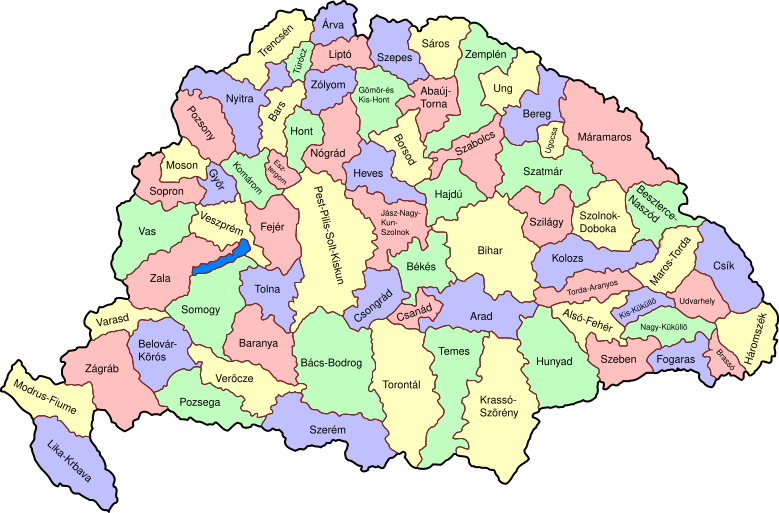
Map of counties of Kingdom of Hungary (Hungary proper and Croatia & Slavonia), 1886-1918. I have organised this into layers: Three layers of paths for the counties, for the county borders, and for external border. and one layer for the text labels. I have added basic styles and classified all elements. I have given all elements reasonable IDs the counties (the county name) and the borders (the names of the counties on each side) and the text labels (the names of the counties, with underscores indicating where they are split across labels). The counties are classed into four styles to make a four colour map, of course the colours can be changed just by changing the style (there as a fifth style for Lake Balaton, which does not show up very well on tis uploaded one). The main thing now is to fix the text styles. |
||
| التاريخ | (UTC) | ||
| المصدر | |||
| المؤلف |
|
||
| إصدارات أخرى |
|

| هذا رسمٌ مُعَدَّلٌ رقميَّاً من النسخة الأصليَّة. التعديلات هي: As described - added more useful metadata and structure. يُمكن الاطلاع على النسخة الأصليَّة هنا: Kingdom of Hungary counties.svg:
|
أنا، صاحب حقوق التأليف والنشر لهذا العمل، أنشر هذا العمل تحت الرخصة التالية:
| أنا، مالِك حقوق تأليف ونشر هذا العمل، أجعله في النِّطاق العامِّ، يسري هذا في أرجاء العالم كلِّه. في بعض البلدان، قد يكون هذا التَّرخيص غيرَ مُمكنٍ قانونيَّاً، في هذه الحالة: أمنح الجميع حق استخدام هذا العمل لأي غرض دون أي شرط ما لم يفرض القانون شروطًا إضافية. |
سجلُّ الرَّفع الأصيل
This image is a derivative work of the following images:
- File:Kingdom_of_Hungary_counties.svg licensed with PD-self
- 2007-08-20T20:25:30Z Xavax 779x513 (240591 Bytes) == Summary == {{Information| |Description= Map of counties of Hungary with Croatia & Slavonia, 1886-1918 |Source=own drawing |Date=April 30, 2006 |Author=[[User:IMeowbot]] |Permission= |other_versions= }} == Licensing == {{P
- 2006-04-30T22:10:47Z IMeowbot 779x513 (228524 Bytes) line weight
- 2006-04-30T21:34:49Z IMeowbot 779x513 (225942 Bytes)
- 2006-04-30T18:34:30Z IMeowbot 779x513 (199213 Bytes) {{Information| |Description= Map of late 1870s Hungary counties |Source=own drawing |Date=April 30, 2006 |Author=[[User:IMeowbot]] |Permission= |other_versions= }}
Uploaded with derivativeFX
تاريخ الملف
اضغط على زمن/تاريخ لرؤية الملف كما بدا في هذا الزمن.
| زمن/تاريخ | صورة مصغرة | الأبعاد | مستخدم | تعليق | |
|---|---|---|---|---|---|
| حالي | 17:57، 5 ديسمبر 2009 | | 779 × 513 (265 كيلوبايت) | SimonTrew | I missed some fixes of Veszprém |
| 17:55، 5 ديسمبر 2009 |  | 779 × 513 (265 كيلوبايت) | SimonTrew | Fix spelling of Vesprém, as I have just done on original. | |
| 14:29، 3 ديسمبر 2009 |  | 779 × 513 (265 كيلوبايت) | SimonTrew | Fix spelling of Pozsony, as I have just done on original work | |
| 13:37، 3 ديسمبر 2009 |  | 779 × 513 (265 كيلوبايت) | SimonTrew | Made four colour map. The text still only uses one style at the moment, this needs to be made to match the four styles used for the four colours for the counties, but this is easier to do once it is uploaded and I can print the png. Sorry if this is "not | |
| 11:29، 3 ديسمبر 2009 |  | 779 × 513 (287 كيلوبايت) | SimonTrew | Fixed the few errors in borders, removed unnecessary style fields from text (Inkscape adds them but they are covered by other fields), text still needs doing better | |
| 01:16، 3 ديسمبر 2009 |  | 779 × 513 (286 كيلوبايت) | SimonTrew | {{Information |Description=Map of counties of Kingdom of Hungary (Hungary proper and Croatia & Slavonia), 1886-1918. I have organised this into layers: Three layers of paths for the counties, for the county borders, and for external border. and one layer |
استخدام الملف
الصفحة التالية تستخدم هذا الملف:
الاستخدام العالمي للملف
الويكيات الأخرى التالية تستخدم هذا الملف:
- الاستخدام في bs.wikipedia.org
- الاستخدام في ceb.wikipedia.org
- الاستخدام في ckb.wikipedia.org
- الاستخدام في da.wikipedia.org
- الاستخدام في de.wikipedia.org
- الاستخدام في en.wikipedia.org
- User talk:Random user 8384993
- Wikipedia talk:WikiProject Hungary/Archive 2
- Module:Location map/data/Kingdom of Hungary/doc
- Wikipedia:Redirects for discussion/Log/2015 April 19
- User:Drkazmer/Jewish centres in the Kingdom of Hungary
- Wikipedia:Graphics Lab/Map workshop/Archive/2017/Sep 2017
- Module:Location map/data/Kingdom of Hungary
- الاستخدام في fa.wikipedia.org
- الاستخدام في fr.wikipedia.org
- الاستخدام في hu.wikipedia.org
- الاستخدام في kn.wikipedia.org
- الاستخدام في pt.wikipedia.org
- الاستخدام في rue.wikipedia.org
- الاستخدام في si.wikipedia.org
- الاستخدام في sr.wikipedia.org
- الاستخدام في tg.wikipedia.org
- الاستخدام في tr.wikipedia.org
- الاستخدام في uz.wikipedia.org
- الاستخدام في war.wikipedia.org