
ملف:Map of Historical Armenia by Britannica 1994.jpg
لا توجد دقة أعلى متوفرة.
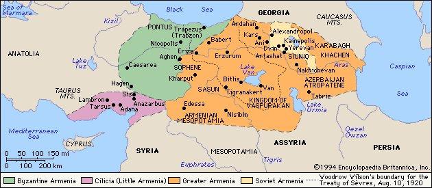
Map_of_Historical_Armenia_by_Britannica_1994.jpg (630 × 275 بكسل حجم الملف: 46 كيلوبايت، نوع MIME: image/jpeg)
| هذا ملف من ويكيميديا كومنز. معلومات من صفحة وصفه مبينة في الأسفل.
كومنز مستودع ملفات ميديا ذو رخصة حرة. |
| This image comes from the 13th edition of the Encyclopædia Britannica or earlier. The copyrights for that book have expired in the United States because the book was first published in the US with the publication occurring before January 1, 1930. As such, this image is in the public domain in the United States. |  |

|
هذه historical map الصورة / الصورتان باستعمال رسومات متجهية ملفات رسوميات شعاعية.
It is recommended to name the SVG file "Map of Historical Armenia by Britannica 1994.svg" - then the template Vector version available (or Vva) does not need the new image name parameter.
|


تاريخ الملف
اضغط على زمن/تاريخ لرؤية الملف كما بدا في هذا الزمن.
| زمن/تاريخ | صورة مصغرة | الأبعاد | مستخدم | تعليق | |
|---|---|---|---|---|---|
| حالي | 14:18، 8 نوفمبر 2009 | | 630 × 275 (46 كيلوبايت) | Elegant's | {{Information |Description={{en|1=Map of Historical Armenia by Britannica 1994}} |Source=[http://www.cilicia.com/pics/picf/vahan/MapofArmenia.jpg cilicia.com] |Author=Encyclopædia Britannica |Date=1994 |Permission= |other_versions= }} |
استخدام الملف
الصفحة التالية تستخدم هذا الملف:
الاستخدام العالمي للملف
الويكيات الأخرى التالية تستخدم هذا الملف:
- الاستخدام في az.wikipedia.org
- الاستخدام في ba.wikipedia.org
- الاستخدام في be.wikipedia.org
- الاستخدام في bg.wikipedia.org
- الاستخدام في de.wikipedia.org
- الاستخدام في en.wikipedia.org
- الاستخدام في hy.wikipedia.org
- الاستخدام في pt.wikipedia.org
- الاستخدام في ru.wikipedia.org
- الاستخدام في sr.wikipedia.org
- الاستخدام في uk.wikipedia.org
- الاستخدام في uz.wikipedia.org