
ملف:Poitou-Charentes region location map.svg

حجم معاينة PNG لذلك الملف ذي الامتداد SVG: 538 × 599 بكسل. الأبعاد الأخرى: 215 × 240 بكسل | 431 × 480 بكسل | 690 × 768 بكسل | 920 × 1٬024 بكسل | 1٬839 × 2٬048 بكسل | 1٬136 × 1٬265 بكسل.
الملف الأصلي (ملف SVG، أبعاده 1٬136 × 1٬265 بكسل، حجم الملف: 538 كيلوبايت)
| هذا ملف من ويكيميديا كومنز. معلومات من صفحة وصفه مبينة في الأسفل. كومنز مستودع ملفات ميديا ذو رخصة حرة. |
ملخص
| موقع آلة التصوير | | هذه وغيرها من الصور في مواقعها على: خريطة الشارع المفتوحة |
|---|
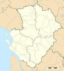
| الوصف |
English: Blank administrative map of the region of Poitou-Charentes, France, for geo-location purpose, with distinct boundaries for regions, departments and arrondissements as set in 2008.
Français : Carte administrative vierge de la région Poitou-Charentes, France, destinée à la géolocalisation, avec limite distincte des régions, départements et arrondissements tels que définis en 2008. Approximate scale: 1:800,000 (precision: 200 m)
Geographic limits of the map:
|
||
| التاريخ | |||
| المصدر |
عمل شخصي
|
||
| المؤلف | Eric Gaba (Sting - fr:Sting) | ||
| الترخيص (إعادة استخدام هذا الملف) |
|
||
| إصدارات أخرى |
|

ترخيص
أنا، صاحب حقوق التأليف والنشر لهذا العمل، أنشر هذا العمل تحت الرخص التالية:
هذا الملفُّ مُرخَّص بموجب رخصة المشاع الإبداعي نسبة المُصنَّف إِلى مُؤَلِّفه - المشاركة بالمثل 3.0 العامة
- يحقُّ لك:
- مشاركة العمل – نسخ العمل وتوزيعه وبثُّه
- إعادة إنتاج العمل – تعديل العمل
- حسب الشروط التالية:
- نسب العمل إلى مُؤَلِّفه – يلزم نسب العمل إلى مُؤَلِّفه بشكل مناسب وتوفير رابط للرخصة وتحديد ما إذا أجريت تغييرات. بالإمكان القيام بذلك بأية طريقة معقولة، ولكن ليس بأية طريقة تشير إلى أن المرخِّص يوافقك على الاستعمال.
- الإلزام بترخيص المُشتقات بالمثل – إذا أعدت إنتاج المواد أو غيرت فيها، فيلزم أن تنشر مساهماتك المُشتقَّة عن الأصل تحت ترخيص الأصل نفسه أو تحت ترخيص مُتوافِقٍ معه.

|
يسمح نسخ وتوزيع و/أو تعديل هذه الوثيقة تحت شروط رخصة جنو للوثائق الحرة، الإصدار 1.2 أو أي إصدار لاحق تنشره مؤسسة البرمجيات الحرة؛ دون أقسام ثابتة ودون نصوص أغلفة أمامية ودون نصوص أغلفة خلفية. نسخة من الرخصة تم تضمينها في القسم المسمى GNU Free Documentation License. |
لك أن تختار الرخصة التي تناسبك.
تاريخ الملف
اضغط على زمن/تاريخ لرؤية الملف كما بدا في هذا الزمن.
| زمن/تاريخ | صورة مصغرة | الأبعاد | مستخدم | تعليق | |
|---|---|---|---|---|---|
| حالي | 20:32، 14 أكتوبر 2008 | | 1٬136 × 1٬265 (538 كيلوبايت) | Sting | == Summary == {{Location|46|08|15|N|00|10|30|W|scale:2000000}} <br/> {{Information |Description={{en|Blank administrative map of the region of Poitou-Charentes, France, for geo-location purpose, with distinct boundaries for region |
استخدام الملف
الصفحة التالية تستخدم هذا الملف:
الاستخدام العالمي للملف
الويكيات الأخرى التالية تستخدم هذا الملف:
- الاستخدام في bg.wikipedia.org
- الاستخدام في ca.wikipedia.org
- الاستخدام في ceb.wikipedia.org
- الاستخدام في cs.wikipedia.org
- الاستخدام في cv.wikipedia.org
- الاستخدام في de.wikipedia.org
- الاستخدام في el.wikipedia.org
- الاستخدام في en.wikipedia.org
- الاستخدام في eo.wikipedia.org
- الاستخدام في es.wikipedia.org
- الاستخدام في fa.wikipedia.org
- الاستخدام في fr.wikipedia.org
- Pictons
- Baptistère Saint-Jean de Poitiers
- Cathédrale Saint-Pierre de Poitiers
- Raids vikings en Poitou et dans la vallée de la Charente
- Modèle:Infobox Port
- Grand Pavois de La Rochelle
- Commanderie d'Ozon
- Abbaye de Saint-Savin-sur-Gartempe
- Église Notre-Dame-de-la-Couldre
- Tumulus de Bougon
- Abbaye Saint-Sauveur de Charroux
- Commanderie Saint-Antoine-de-la-Lande
- Musée Sainte-Croix
- Abbaye de Mauléon
- Pont Neuf (Poitiers)
- Modèle:Géolocalisation/Poitou-Charentes
- Modèle:Carte/Poitou-Charentes
- Wikipédia:Atelier graphique/Cartes/Archives/novembre 2008
- Gare de Lussac-les-Châteaux
- Gare de Mignaloux - Nouaillé
- Projet:Cartographie/Cartes standards/France
- Temple protestant de Saintes
اعرض المزيد من الاستخدام العام لهذا الملف.