
ملف:Pusan Perimeter.jpg
لا توجد دقة أعلى متوفرة.
Pusan_Perimeter.jpg (350 × 572 بكسل حجم الملف: 52 كيلوبايت، نوع MIME: image/jpeg)
| هذا ملف من ويكيميديا كومنز. معلومات من صفحة وصفه مبينة في الأسفل. كومنز مستودع ملفات ميديا ذو رخصة حرة. |
ملخص
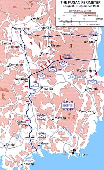
| الوصف |
English: Map of the Pusan Perimeter, August 1950. |
| المصدر | This map was created by the Center for Military History and used in the brochure "The Korean War: The Outbreak" located at [1]. |
| المؤلف | United States Army Center of Military History |
| إصدارات أخرى |
|
.jpg)
.jpg)
.jpg)
.jpg)
.jpg)
ترخيص
| This image is in the public domain because it contains materials that originally came from the United States Army Center of Military History, subject to the following qualification.
Note: The images of all badges, insignia, decorations and medals on the "CMH Online" web site are produced by the United States Army Institute of Heraldry and protected by Title 18, United States Code, Section 704 and the Code of Federal Regulations (32 CFR, Part 507). Permission to use these images for commercial purposes must be obtained from The Institute of Heraldry prior to their use. |

|
سجلُّ الرَّفع الأصيل
صفحة الوصف الأصلية كانت هنا، تشير جميع أسماء المستخدمين التالية إلى en.wikipedia.
تاريخ الملف
اضغط على زمن/تاريخ لرؤية الملف كما بدا في هذا الزمن.
| زمن/تاريخ | صورة مصغرة | الأبعاد | مستخدم | تعليق | |
|---|---|---|---|---|---|
| حالي | 01:13، 15 مارس 2008 | | 350 × 572 (52 كيلوبايت) | Donostiarra~commonswiki | {{Information |Description={{en|Map of the Pusan Perimeter, August 1950. This map was created by the Center for Military History and used in the brochure "The Korean War: The Outbreak" located at [http://www.army.mil/cmh-pg/brochures/KW-Outbreak/outbreak. |
استخدام الملف
الصفحة التالية تستخدم هذا الملف:
الاستخدام العالمي للملف
الويكيات الأخرى التالية تستخدم هذا الملف:
- الاستخدام في cs.wikipedia.org
- الاستخدام في de.wikipedia.org
- الاستخدام في en.wikipedia.org
- الاستخدام في es.wikipedia.org
- الاستخدام في fr.wikipedia.org
- الاستخدام في he.wikipedia.org
- الاستخدام في ko.wikipedia.org
- الاستخدام في no.wikipedia.org
- الاستخدام في pl.wikipedia.org
- الاستخدام في pt.wikipedia.org
- الاستخدام في ru.wikipedia.org
- الاستخدام في simple.wikipedia.org
- الاستخدام في uk.wikipedia.org
- الاستخدام في vi.wikipedia.org