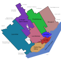
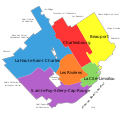
ملف:Quebec - Arrondissements.svg
المظهر

حجم معاينة PNG لذلك الملف ذي الامتداد SVG: 623 × 600 بكسل. الأبعاد الأخرى: 249 × 240 بكسل | 498 × 480 بكسل | 798 × 768 بكسل | 1٬063 × 1٬024 بكسل | 2٬127 × 2٬048 بكسل | 1٬133 × 1٬091 بكسل.
الملف الأصلي (ملف SVG، أبعاده 1٬133 × 1٬091 بكسل، حجم الملف: 26 كيلوبايت)
تاريخ الملف
اضغط على زمن/تاريخ لرؤية الملف كما بدا في هذا الزمن.
| زمن/تاريخ | صورة مصغرة | الأبعاد | مستخدم | تعليق | |
|---|---|---|---|---|---|
| حالي | 18:28، 16 مايو 2008 |  | 1٬133 × 1٬091 (26 كيلوبايت) | Essin | Spelling edit: Stoneham-et-Tewksbury -> Stoneham-et-Tewkesbury |
| 20:43، 9 ديسمبر 2007 |  | 1٬133 × 1٬091 (26 كيلوبايت) | Boréal | {{Information |Description= {{fr}} Carte des arrondissements de la ville de Québec (Québec, Canada) en 2007. {{en}} Maps of the Boroughs ("Arrondissements") of Quebec City (Quebec, Canada), 2007. |Source=Own work, made with Inkscape |Date=2007-12-09 |Au | |
| 20:35، 9 ديسمبر 2007 |  | 1٬133 × 1٬091 (26 كيلوبايت) | Boréal | {{Information |Description= {{fr}} Carte des arrondissements de la ville de Québec (Québec, Canada) en 2007. {{en}} Maps of the Boroughs ("Arrondissements") of Quebec City (Quebec, Canada), 2007. |Source=Own work, made with Inkscape |Date=2007-12-09 |Au | |
| 20:30، 9 ديسمبر 2007 |  | 1٬133 × 1٬091 (25 كيلوبايت) | Boréal | {{Information |Description= {{fr}} Carte des arrondissements de la ville de Québec (Québec, Canada) en 2007. {{en}} Maps of the Boroughs ("Arrondissements") of Quebec City (Quebec, Canada), 2007. |Source=Own work, made with Inkscape |Date=2007-12-09 |Au |
استخدام الملف
الصفحة التالية تستخدم هذا الملف:
الاستخدام العالمي للملف
الويكيات الأخرى التالية تستخدم هذا الملف:
- الاستخدام في de.wikipedia.org
- الاستخدام في en.wikipedia.org
- الاستخدام في eo.wikipedia.org
- الاستخدام في fr.wikipedia.org
- الاستخدام في la.wikipedia.org
- الاستخدام في ru.wikipedia.org

