
ملف:STS035-502-4.jpg

حجم هذه المعاينة: 595 × 600 بكسل. الأبعاد الأخرى: 238 × 240 بكسل | 476 × 480 بكسل | 762 × 768 بكسل | 1٬016 × 1٬024 بكسل | 2٬031 × 2٬048 بكسل | 3٬904 × 3٬936 بكسل.
الملف الأصلي (3٬904 × 3٬936 بكسل حجم الملف: 10٫83 ميجابايت، نوع MIME: image/jpeg)
| هذا ملف من ويكيميديا كومنز. معلومات من صفحة وصفه مبينة في الأسفل.
كومنز مستودع ملفات ميديا ذو رخصة حرة. |
ملخص
| الوصف |
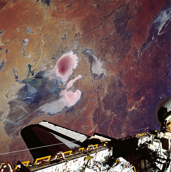
English: Lake Eyre is large in aerial extent (covers about 3600 square miles—9300 square kilometers), and its total drainage basin is even larger. The lake is divided into two unequal parts: Lake Eyre North and a much smaller Lake Eyre South. The two basins are connected by a narrow canal known as the Goyder Channel. Three specific “bays” are identified at the southern end of the north basin: Belt Bay (whitish lobe, southwest); Madigan Bay (multicolored, southeast); and the thin, elongated Jackboot Bay which is located between the larger bays. Belt Bay and Madigan Bay have the thickest crusts of dissolved salts--up to 15 inches (40 centimeters) on their surfaces. Lake Eyre is the lowest point in Australia at about 50 feet (15 meters) below sea level. This lake is also Australia's largest lakebed, although it is an ephemeral salt lake that receives less than 5 inches (125 millimeters) annual average precipitation. Records indicate that the lake has only been completely filled with water three times in the 20th century (1950, 1974, and 1984). In this photo the lake shows Eyre drying down from a higher level in October. The light, colored feature in the upper right corner of the picture is the northern end of Lake Torrens which is also another ephemeral lake. Part of the Space Shuttle cargo bay is visible along the bottom edge of the image. |
| التاريخ | |
| المصدر | http://eol.jsc.nasa.gov/scripts/sseop/photo.pl?mission=STS035&roll=502&frame=4 |
| المؤلف | NASA/STS-35 |
فُهرِست هذه الصُّورة أَو هذا التَّسجيل المرئي لدى مركز جونسون للفضاء التَّابعة لوكالة الفضاء الأَمريكيَّة (ناسا) تحت المُعرِّف STS035-502-4. لا يُشير هذه الوَسم إلى حالة حقوق التَّأليف والنَّشر الخاصَّة بالعمل المُرفَق؛ لا يزال وَسم حقوق التَّأليف والنَّشر مَطلُوباً، راجع كومنز:ترخيص لمزيدٍ من المعلومات. لغات أخرى:
|
ترخيص
يقع هذا الملفُّ في النِّطاق العامِّ في الولايات المُتحدة لأنَّه أُنشِئ مِن قبل مُختبر علوم الصُّور وتحليلها في مركز جُونسُون للفضاء التَّابِع لوَكالة الفضاء الأَمريكيَّة. تنصُّ سياسة حقوق التَّأليف والنَّشر لوَكالة الفضاء الأَمريكيَّة على أنَّ "المواد الَّتي تُنتجها الوَكالة غير مَحميَّةٍ بحقوق التَّأليف والنَّشر ما لم يُذكر خلاف ذلك". انظر (دليل استعمال الوسائِط الخاصِّ بالوَكالة أو شروط استعمال الصُّور الضُّوئِيَّة التي التقطها روَّاد الفضاء).
مَصدَر الصُّورة: STS035-502-4.
|
تاريخ الملف
اضغط على زمن/تاريخ لرؤية الملف كما بدا في هذا الزمن.
| زمن/تاريخ | صورة مصغرة | الأبعاد | مستخدم | تعليق | |
|---|---|---|---|---|---|
| حالي | 12:13، 12 مايو 2013 | | 3٬904 × 3٬936 (10٫83 ميجابايت) | Ras67 | original |
| 07:24، 14 أغسطس 2011 |  | 2٬000 × 2٬016 (685 كيلوبايت) | Exploitcorporations |
استخدام الملف
الصفحة التالية تستخدم هذا الملف:
الاستخدام العالمي للملف
الويكيات الأخرى التالية تستخدم هذا الملف:
- الاستخدام في bg.wikipedia.org
- الاستخدام في ca.wikipedia.org
- الاستخدام في en.wikipedia.org
- الاستخدام في es.wikipedia.org
- الاستخدام في et.wikipedia.org
- الاستخدام في ja.wikipedia.org
- الاستخدام في sk.wikipedia.org
- الاستخدام في sr.wikipedia.org
- الاستخدام في uk.wikipedia.org
- الاستخدام في zh-yue.wikipedia.org