
ملف:Tabula hungariae.jpg

حجم هذه المعاينة: 421 × 600 بكسل. الأبعاد الأخرى: 168 × 240 بكسل | 337 × 480 بكسل | 539 × 768 بكسل | 719 × 1٬024 بكسل | 1٬438 × 2٬048 بكسل | 3٬236 × 4٬609 بكسل.
الملف الأصلي (3٬236 × 4٬609 بكسل حجم الملف: 3٫27 ميجابايت، نوع MIME: image/jpeg)
| هذا ملف من ويكيميديا كومنز. معلومات من صفحة وصفه مبينة في الأسفل. كومنز مستودع ملفات ميديا ذو رخصة حرة. |
ملخص
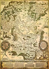
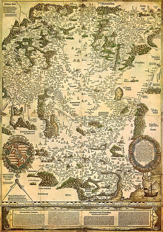
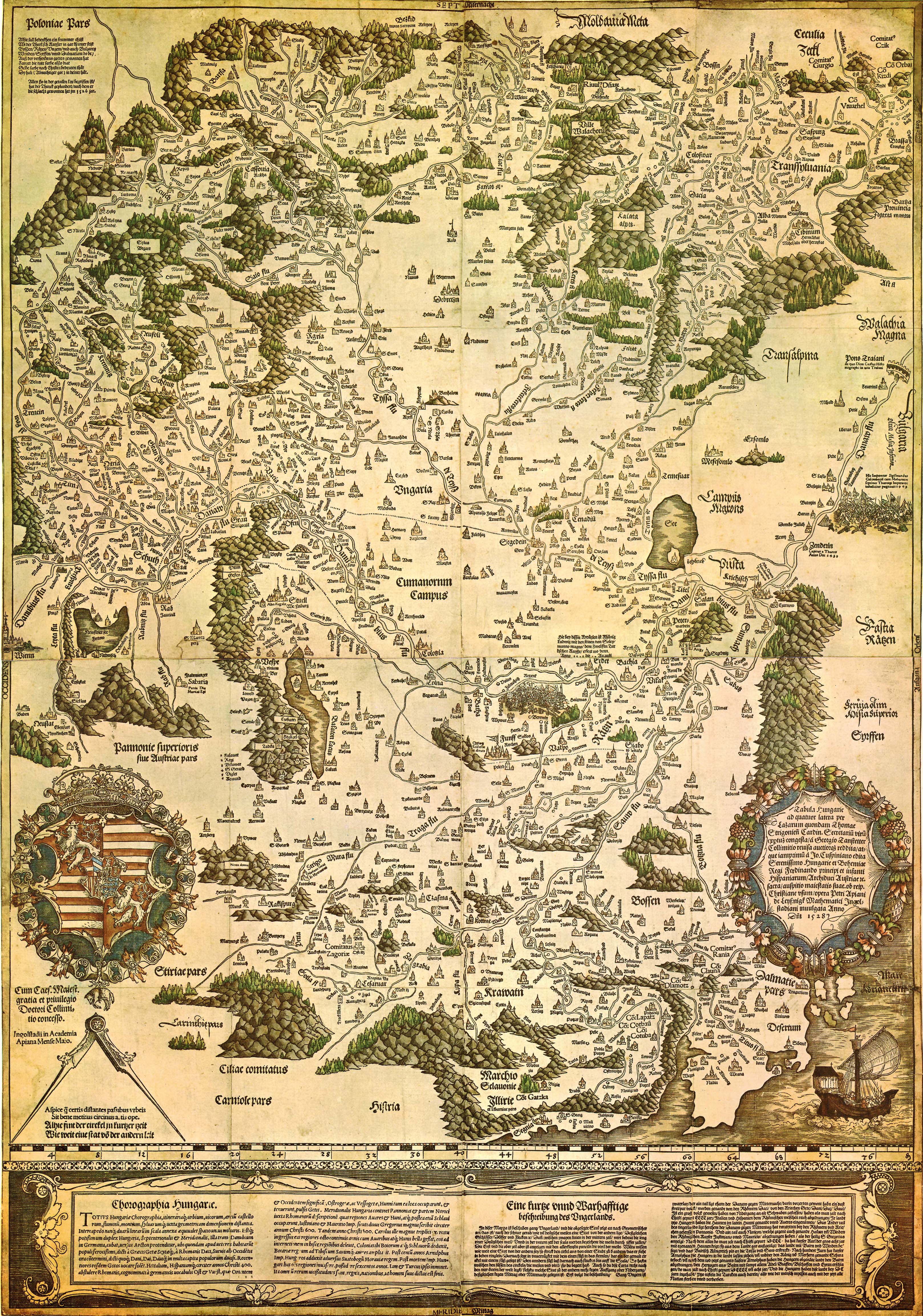
| Tabula Hungariae
|
||
|---|---|---|
| المؤلف |
Lázár deák (Lazarus secretarius) |
 |
| العنوان |
اللاتينية: Tabula Hungarie ad quatuor latera Tabula Hungariae |
|
| المطبعة | ||
| نوع العمل |
antique map |
|
| الوصف |
Magyar: A Tabula Hungariae vagy Lázár térképe Magyarország első nyomtatott térképe, amelyet a feltehetően a magyar Lázár deák készített Српски / srpski: Lazarusova karta Ugarske iz 1528. godine na kojoj je na mestu današnjeg Novog Sada ubeleženo naselje Bistritz (Bistrica) |
|
| التاريخ | بين ١٥٢٦ و ١٥٢٨ | |
| تاريخ النشر |
١٥٢٨ |
|
| المجموعة | ||
| المراجع | ||
| ملف الضبط الاستنادي | ||
| المصدر/المصور | http://lazarus.elte.hu/hun/maps/lazar150.jpg | |
| إصدارات أخرى |
|
|


ترخيص
|
هذا العمل يقع في النَّطاق العامّ في بلد المنشأ وفي البلدان الأخرى والمناطق التي تمتدُّ فيها مدة حقوق التَّأليف والنشر لتغطي زمن حياة المُؤلِّف و 100 سنةً بعد وفاته أو أقل من ذلك. يقع هذ العمل في النَّطاق العامِّ في الولايات المُتحدة الأمريكيَّة لأنَّه نُشِرَ (أو سُجِّل لدى مكتب الولايات المُتحدة لحقوق التَّأليف والنَّشر) قبل ١ يناير ١٩٢٩. | |
| هذا الملفُّ مَلحُوظُ بصفته غيرَ مُقيَّدٍ بحقوق التَّأليف والنشر، وهذا يشمل أيضاً الحقوق المُجاوِرة أَو ذات الصلة جميعُها. | |
تاريخ الملف
اضغط على زمن/تاريخ لرؤية الملف كما بدا في هذا الزمن.
| زمن/تاريخ | صورة مصغرة | الأبعاد | مستخدم | تعليق | |
|---|---|---|---|---|---|
| حالي | 23:02، 29 أغسطس 2009 | | 3٬236 × 4٬609 (3٫27 ميجابايت) | Qorilla | {{Information |Description={{en|1=Tabula Hungariae, first printed map of Hungary}} |Source=Hungarian Wikipedia |Author=Lázár deák (Lazarus secretarius) |Date=somewhere between 1526-1528 |Permission= |other_versions= }} Category:Old maps of Hungary |
استخدام الملف
الصفحة التالية تستخدم هذا الملف:
الاستخدام العالمي للملف
الويكيات الأخرى التالية تستخدم هذا الملف:
- الاستخدام في bn.wikipedia.org
- الاستخدام في bs.wikipedia.org
- الاستخدام في ca.wikipedia.org
- الاستخدام في de.wikipedia.org
- الاستخدام في el.wikipedia.org
- الاستخدام في en.wikipedia.org
- Pannonia
- Treaty of Trianon
- Hungarian Revolution of 1956
- Austro-Hungarian Compromise of 1867
- Military Frontier
- Hungarian nobility
- History of Hungary before the Hungarian conquest
- Hungarian prehistory
- Kingdom of Hungary (1526–1867)
- History of geography
- Georg Tannstetter
- Upper Hungary
- History of the Jews in Hungary
- Music history of Hungary
- Bistrica, Novi Sad
- Lands of the Crown of Saint Stephen
- History of Transylvania
- Template:History of Hungary
- Hungarian People's Republic
- Principality of Transylvania (1570–1711)
- Military history of Hungary
- First Hungarian Republic
- Ottoman Hungary
- Hungary between the World Wars
- Principality of Hungary
- Hungarian Revolution of 1848
- Rákóczi's War of Independence
- Eastern Hungarian Kingdom
- Kingdom of Hungary (1920–1946)
- Hungary in World War I
- Second Hungarian Republic
- Mugel
اعرض المزيد من الاستخدام العام لهذا الملف.