
ملف:Westwood neighborhood, Los Angeles, California.jpg
لا توجد دقة أعلى متوفرة.
Westwood_neighborhood,_Los_Angeles,_California.jpg (730 × 563 بكسل حجم الملف: 109 كيلوبايت، نوع MIME: image/jpeg)
| هذا ملف من ويكيميديا كومنز. معلومات من صفحة وصفه مبينة في الأسفل. كومنز مستودع ملفات ميديا ذو رخصة حرة. |
ملخص
| الوصف |
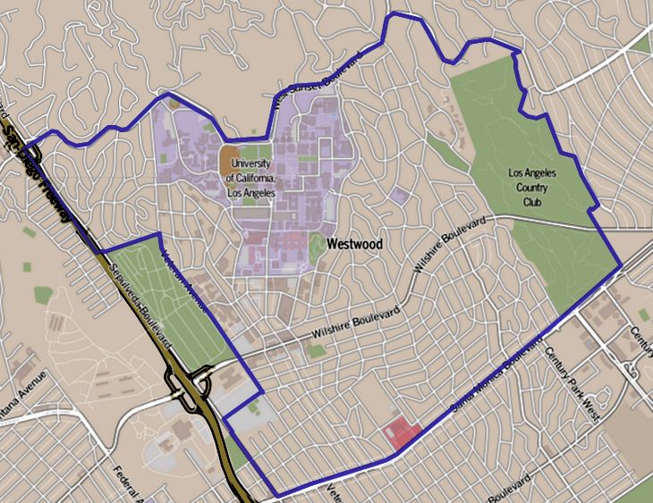
English: Map of Westwood, California, as delineated by the Los Angeles Times Boundary map as drawn by the Los Angeles Times on a CC-by-SA background. Note at bottom right of map on the L.A. Times website noted above says "CC-by-SA" (which gives permission to use the map). There is a link there to https://creativecommons.org/licenses/by-sa/2.0, which explains the meaning thereof. The base map is credited to http://www.openstreetmap.org/ The Times spells all this out at http://projects.latimes.com/mapping-la/about/#the-data |
| التاريخ | تاريخ غير معروف |
| المصدر | http://projects.latimes.com/mapping-la/neighborhoods/neighborhood/westwood/ |
| المؤلف | Los Angeles Times |
| الترخيص (إعادة استخدام هذا الملف) |
http://projects.latimes.com/mapping-la/neighborhoods/neighborhood/westwood/ |
ترخيص
هذا الملف مُرخَّص برخصة المشاع الإبداعي العامة المُلزِمة بنسب العمل إلى مُؤَلِّفه 2.0
نسب العمل لمُؤَلِّفه: Open Street Map contributors
- يحقُّ لك:
- مشاركة العمل – نسخ العمل وتوزيعه وبثُّه
- إعادة إنتاج العمل – تعديل العمل
- حسب الشروط التالية:
- نسب العمل إلى مُؤَلِّفه – يلزم نسب العمل إلى مُؤَلِّفه بشكل مناسب وتوفير رابط للرخصة وتحديد ما إذا أجريت تغييرات. بالإمكان القيام بذلك بأية طريقة معقولة، ولكن ليس بأية طريقة تشير إلى أن المرخِّص يوافقك على الاستعمال.
سجلُّ الرَّفع الأصيل
صفحة الوصف الأصلية كانت هنا، تشير جميع أسماء المستخدمين التالية إلى en.wikipedia.
| زمن/تاريخ | الأبعاد | مستخدم | تعليق |
|---|---|---|---|
| 2013-06-27 14:08 | 730×563× (111695 bytes) | GeorgeLouis | Uploading a file from a free published source using [[Wikipedia:File_Upload_Wizard|File Upload Wizard]] |
تاريخ الملف
اضغط على زمن/تاريخ لرؤية الملف كما بدا في هذا الزمن.
| زمن/تاريخ | صورة مصغرة | الأبعاد | مستخدم | تعليق | |
|---|---|---|---|---|---|
| حالي | 21:58، 1 ديسمبر 2014 | | 730 × 563 (109 كيلوبايت) | Arthunter | Transferred from en.wikipedia |
استخدام الملف
الصفحة التالية تستخدم هذا الملف:
الاستخدام العالمي للملف
الويكيات الأخرى التالية تستخدم هذا الملف:
- الاستخدام في azb.wikipedia.org
- الاستخدام في en.wikipedia.org
- الاستخدام في es.wikipedia.org
- الاستخدام في fa.wikipedia.org
- الاستخدام في fr.wikipedia.org
- الاستخدام في it.wikipedia.org
- الاستخدام في ro.wikipedia.org
- الاستخدام في sv.wikipedia.org
- الاستخدام في uk.wikipedia.org
- الاستخدام في ur.wikipedia.org
- الاستخدام في www.wikidata.org
- الاستخدام في zh.wikipedia.org