
ملف:EXTERIOR VIEW, FRONT ELEVATION - Corry Homestead, Corry House, State Route 69, 10 miles South of Jasper (244 School Street), Oakman, Walker County, AL HABS ALA,64-OAK,A-1.tif

حجم معاينة JPG لذلك الملف ذي الامتداد TIF: 800 × 584 بكسل. الأبعاد الأخرى: 320 × 234 بكسل | 640 × 468 بكسل | 1٬024 × 748 بكسل | 1٬280 × 935 بكسل | 2٬560 × 1٬870 بكسل | 5٬000 × 3٬653 بكسل.
الملف الأصلي (5٬000 × 3٬653 بكسل حجم الملف: 17٫42 ميجابايت، نوع MIME: image/tiff)
| هذا ملف من ويكيميديا كومنز. معلومات من صفحة وصفه مبينة في الأسفل. كومنز مستودع ملفات ميديا ذو رخصة حرة. |
ملخص
| EXTERIOR VIEW, FRONT ELEVATION - Corry Homestead, Corry House, State Route 69, 10 miles South of Jasper (244 School Street), Oakman, Walker County, AL | ||||
|---|---|---|---|---|
| مصور |
Related names:
|
|||
| العنوان |
EXTERIOR VIEW, FRONT ELEVATION - Corry Homestead, Corry House, State Route 69, 10 miles South of Jasper (244 School Street), Oakman, Walker County, AL |
|||
| المكان المُصوَّر | Alabama; Walker County; Oakman | |||
| التاريخ | Documentation compiled after 1933 | |||
| الأبعاد | 8 x 10 in. | |||
| الموقع الحالي |
Library of Congress Prints and Photographs Division Washington, D.C. 20540 USA http://hdl.loc.gov/loc.pnp/pp.print |
|||
| رقم التصنيف |
HABS ALA,64-OAK,A-1 |
|||
| الإشادة |
|
|||
| ملاحظات |
|
|||
| المصدر | https://www.loc.gov/pictures/item/al1160.photos.046569p | |||
| الترخيص (إعادة استخدام هذا الملف) |
|
|||

| موقع الكائن | | هذه وغيرها من الصور في مواقعها على: خريطة الشارع المفتوحة |
|---|
تاريخ الملف
اضغط على زمن/تاريخ لرؤية الملف كما بدا في هذا الزمن.
| زمن/تاريخ | صورة مصغرة | الأبعاد | مستخدم | تعليق | |
|---|---|---|---|---|---|
| حالي | 03:08، 1 يوليو 2014 | 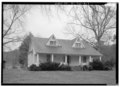 | 5٬000 × 3٬653 (17٫42 ميجابايت) | Fæ | GWToolset: Creating mediafile for Fæ. HABS batch upload 29 June 2014 (101:150) |
استخدام الملف
الصفحة التالية تستخدم هذا الملف:
الاستخدام العالمي للملف
الويكيات الأخرى التالية تستخدم هذا الملف:
- الاستخدام في arz.wikipedia.org
- الاستخدام في ca.wikipedia.org
- الاستخدام في ceb.wikipedia.org
- الاستخدام في ce.wikipedia.org
- الاستخدام في cy.wikipedia.org
- الاستخدام في es.wikipedia.org
- الاستخدام في eu.wikipedia.org
- الاستخدام في fr.wikipedia.org
- الاستخدام في ht.wikipedia.org
- الاستخدام في it.wikipedia.org
- الاستخدام في lld.wikipedia.org
- الاستخدام في no.wikipedia.org
- الاستخدام في pl.wikipedia.org
- الاستخدام في pt.wikipedia.org
- الاستخدام في sr.wikipedia.org
- الاستخدام في tt.wikipedia.org
- الاستخدام في uk.wikipedia.org
- الاستخدام في uz.wikipedia.org
- الاستخدام في vi.wikipedia.org
- الاستخدام في www.wikidata.org
- الاستخدام في zh-min-nan.wikipedia.org