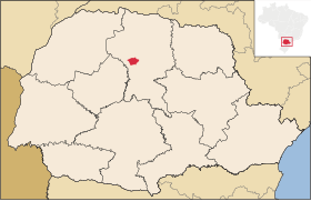
بوم سوسيسو، بارانا
المظهر
| بوم سوسيسو، بارانا | |||
|---|---|---|---|
|
|||
 |
|||
 |
|||
| الإحداثيات | 23°42′36″S 51°45′50″W / 23.71°S 51.763888888889°W | ||
| تقسيم إداري | |||
| البلد | |||
| التقسيم الأعلى | بارانا | ||
| خصائص جغرافية | |||
| المساحة | 322.755 كيلومتر مربع | ||
| ارتفاع | 580 متر، و544 متر | ||
| عدد السكان | |||
| عدد السكان | 6581 (2022)[1] | ||
| الكثافة السكانية | 20.39 نسمة/كم2 | ||
| رمز الهاتف | 43 | ||
| رمز جيونيمز | 6322700 | ||
| تعديل مصدري - تعديل | |||
بوم سوسيسو بلدية في ولاية بارانا في المنطقة الجنوبية من البرازيل.[2][3][4][5]
المراجع
[عدل]- ^ https://www.ibge.gov.br/estatisticas/sociais/populacao/22827-censo-demografico-2022.html?edicao=37225. اطلع عليه بتاريخ 2023-10-24.
{{استشهاد ويب}}:|url=بحاجة لعنوان (مساعدة) والوسيط|title=غير موجود أو فارغ (من ويكي بيانات) (مساعدة) - ^ "Divisão Territorial do Brasil" (بالبرتغالية). Divisão Territorial do Brasil e Limites Territoriais, Instituto Brasileiro de Geografia e Estatística (IBGE). 1 Jul 2008. Archived from the original on 2020-08-06. Retrieved 2009-12-17.
- ^ "Estimativas da população para 1º de julho de 2009" (بالبرتغالية). Estimativas de População, Instituto Brasileiro de Geografia e Estatística (IBGE). 14 Aug 2009. Archived from the original (نسق المستندات المنقولة) on 2020-08-06. Retrieved 2009-12-17.
- ^ "Ranking decrescente do IDH-M dos municípios do Brasil" (بالبرتغالية). Atlas do Desenvolvimento Humano, Programa das Nações Unidas para o Desenvolvimento (PNUD). 2000. Archived from the original on 2009-10-03. Retrieved 2009-12-17.
- ^ "Produto Interno Bruto dos Municípios 2002-2005" (PDF) (بالبرتغالية). Instituto Brasileiro de Geografia e Estatística (IBGE). 19 Dec 2007. Archived from the original (PDF) on 2008-10-02. Retrieved 2009-12-17.


